Karachi elevation
Karachi (Sindh, Karāchi District), Pakistan elevation is 8 meters and Karachi elevation in feet is 26 ft above sea level [src 1]. Karachi is a seat of a first-order administrative division (feature code) with elevation that is 338 meters (1109 ft) smaller than average city elevation in Pakistan.
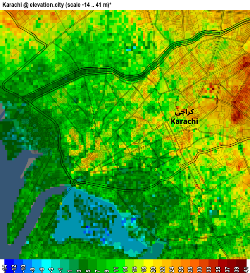
Below is the Elevation map of Karachi, which displays elevation range with different colors. Scale of the first map is from -14 to 41 m (-46 to 135 ft) with average elevation of 11.9 meters (=39 ft) [note 1]
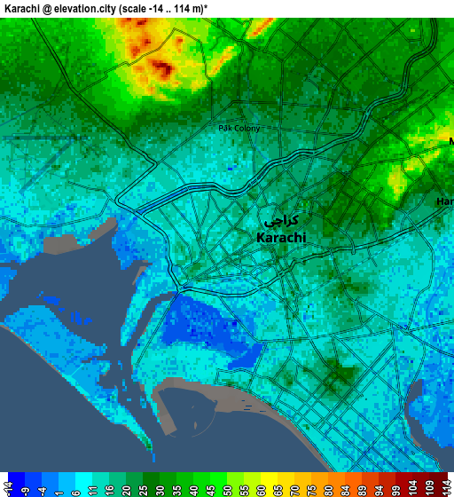
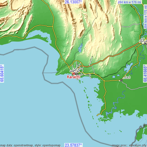
These maps also provides idea of topography and contour of this city, they are displayed at different zoom levels. More info about maps, scale and edge coordinates you can find below images.
| \ | Map #1 | Map #2 | Topo.Map |
| Scale [m] | -14..41 m | -14..114 m | × |
| Scale [ft] | -46..135 ft | -46..374 ft | × |
| Average | 11.9 m = 39 ft | 20.3 m = 67 ft | × |
| Width | 8.87 km = 5.5 mi | 17.73 km = 11 mi | 283.7 km = 176.3 mi |
| Height | 8.87 km = 5.5 mi | 17.73 km = 11 mi | 283.7 km = 176.3 mi |
| ↑Max Latitude | 24.900667° | 24.94052° | 26.13007° |
| Latitude at center | 24.8608° | 24.8608° | 24.8608° |
| ↓Min Latitude | 24.820921° | 24.781028° | 23.57837° |
| ← Min Longitude | 66.966455° | 66.922509° | 65.60415° |
| Longitude center | 67.0104° | 67.0104° | 67.0104° |
| →Max Longitude | 67.054345° | 67.098291° | 68.41665° |
Nearby cities:
Cities around Karachi sort by population:
• Malir Cantonment elevation 52 m
21.8 km,  65°
65°
• Thatta 17 m
93 km,  97°
97°
• Gharo 5 m
59.5 km, 102°
• Uthal 43 m
112.2 km,  339°
339°
• Chuhar Jamali 9 m
112 km,  117°
117°
• Gadani 9 m
40.1 km,  315°
315°
• Daromehar 17 m
118.2 km,  93°
93°
• Jati 11 m
139 km,  113°
113°
• Mirpur Bhtoro 12 m
127 km, 96°
• Mirpur Sakro 8 m
71.5 km, 119°
• Bulri 11 m
133.5 km, 89°
• Keti Bandar 3 m
91.3 km,  150°
150°
Multilingual:
 En español:
Karachi elevación 8 m.
 En France:
Karâchi élévation 8 m.


Sources and notes:
- [note 1] Map square and city borders are not equal. Map elevation data is calculated only from area inside that square.
- [src 1] Elevation data from geonames database provided with same terms of usage.
- [src 2] The elevation map of Karachi is generated using elevation data from NASA's 3 arcsec (90m) resolution SRTM data.
- [src 3] Base (background) map © OpenStreetMap contributors tiles are generated by Geofabrik and OpenTopoMap.
Copyright & License:
This Karachi Elevation Map is licensed under CC BY-SA. You may reuse any part from this page, if you give a proper credit by linking to this URL:
 More info on terms of use page.