Pind Dadan Khan elevation
Pind Dadan Khan (Punjab), Pakistan elevation is 205 meters and Pind Dadan Khan elevation in feet is 673 ft above sea level [src 1]. Pind Dadan Khan is a populated place (feature code) with elevation that is 141 meters (463 ft) smaller than average city elevation in Pakistan.
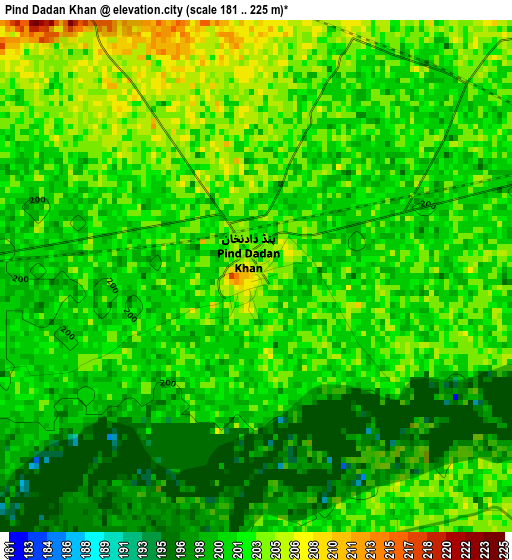
Below is the Elevation map of Pind Dadan Khan, which displays elevation range with different colors. Scale of the first map is from 181 to 225 m (594 to 738 ft) with average elevation of 201.3 meters (=660 ft) [note 1]
These maps also provides idea of topography and contour of this city, they are displayed at different zoom levels. More info about maps, scale and edge coordinates you can find below images.
| \ | Map #1 | Map #2 | Topo.Map |
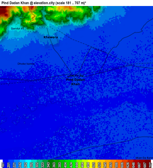
| Scale [m] | 181..225 m | 181..707 m | × |
| Scale [ft] | 594..738 ft | 594..2320 ft | × |
| Average | 201.3 m = 660 ft | 221.7 m = 727 ft | × |
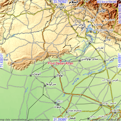
| Width | 8.23 km = 5.1 mi | 16.47 km = 10.2 mi | 263.5 km = 163.7 mi |
| Height | 8.23 km = 5.1 mi | 16.47 km = 10.2 mi | 263.5 km = 163.7 mi |
| ↑Max Latitude | 32.62364° | 32.660644° | 33.76362° |
| Latitude at center | 32.58662° | 32.58662° | 32.58662° |
| ↓Min Latitude | 32.549585° | 32.512535° | 31.39396° |
| ← Min Longitude | 73.000615° | 72.956669° | 71.63831° |
| Longitude center | 73.04456° | 73.04456° | 73.04456° |
| →Max Longitude | 73.088505° | 73.132451° | 74.45081° |
Nearby cities:
Cities around Pind Dadan Khan sort by population:
• Mandi Bahauddin elevation 223 m
41.8 km,  89°
89°
• Chakwal 523 m
42.4 km,  335°
335°
• Bhalwal 196 m
38.2 km,  201°
201°
• Malakwal City 211 m
16.1 km,  102°
102°
• Malakwal 209 m
16.2 km, 102°
• Khewra 374 m
7.6 km, 335°
• Bhera 201 m
17.2 km,  227°
227°
• Kallar Kahar 644 m
38.9 km,  303°
303°
• Choa Saidan Shah 625 m
15.8 km, 339°
• Liliani 194 m
43.4 km,  191°
191°
• Dandot RS 281 m
8.9 km,  313°
313°
• Khandowa 779 m
33.8 km, 300°
Multilingual:
 En español:
Pind Dadan Khan elevación 205 m.
 En France:
Pind Dadan Khan élévation 205 m.
 Auf Deutsch:
Pind Dadan Khan höhe über dem Meeresspiegel ist 205 m.

Sources and notes:
- [note 1] Map square and city borders are not equal. Map elevation data is calculated only from area inside that square.
- [src 1] Elevation data from geonames database provided with same terms of usage.
- [src 2] The elevation map of Pind Dadan Khan is generated using elevation data from NASA's 3 arcsec (90m) resolution SRTM data.
- [src 3] Base (background) map © OpenStreetMap contributors tiles are generated by Geofabrik and OpenTopoMap.
Copyright & License:
This Pind Dadan Khan Elevation Map is licensed under CC BY-SA. You may reuse any part from this page, if you give a proper credit by linking to this URL:
 More info on terms of use page.