Aga elevation
Aga (Calabarzon, Province of Batangas), Philippines elevation is 368 meters and Aga elevation in feet is 1207 ft above sea level [src 1]. Aga is a populated place (feature code) with elevation that is 280 meters (919 ft) bigger than average city elevation in Philippines.
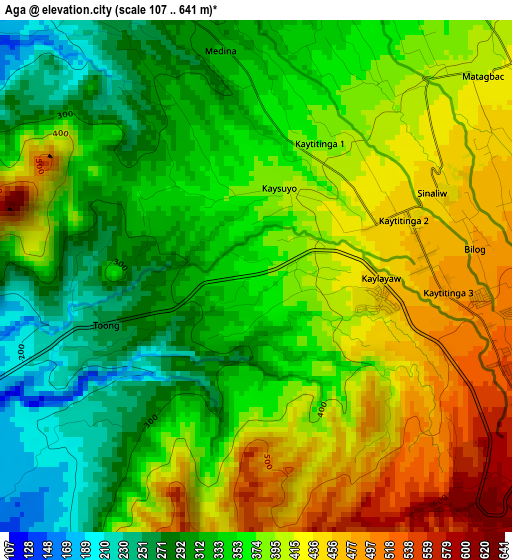
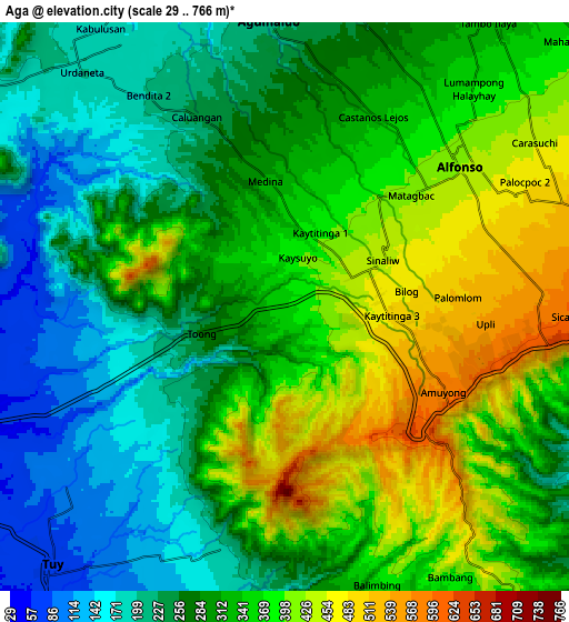
Below is the Elevation map of Aga, which displays elevation range with different colors. Scale of the first map is from 107 to 641 m (351 to 2103 ft) with average elevation of 371.3 meters (=1218 ft) [note 1]
These maps also provides idea of topography and contour of this city, they are displayed at different zoom levels. More info about maps, scale and edge coordinates you can find below images.

| \ | Map #1 | Map #2 | Topo.Map |
| Scale [m] | 107..641 m | 29..766 m | × |
| Scale [ft] | 351..2103 ft | 95..2513 ft | × |
| Average | 371.3 m = 1218 ft | 314.8 m = 1033 ft | × |
| Width | 9.48 km = 5.9 mi | 18.96 km = 11.8 mi | 303.3 km = 188.5 mi |
| Height | 9.48 km = 5.9 mi | 18.96 km = 11.8 mi | 303.3 km = 188.5 mi |
| ↑Max Latitude | 14.139118° | 14.181728° | 15.45621° |
| Latitude at center | 14.0965° | 14.0965° | 14.0965° |
| ↓Min Latitude | 14.053874° | 14.01124° | 12.72864° |
| ← Min Longitude | 120.758225° | 120.714279° | 119.39592° |
| Longitude center | 120.80217° | 120.80217° | 120.80217° |
| →Max Longitude | 120.846115° | 120.890061° | 122.20842° |
Nearby cities:
Cities around Aga sort by population:
• General Emilio Aguinaldo elevation 213 m
9.8 km,  355°
355°
• Alfonso 413 m
7.4 km,  48°
48°
• Mangas 498 m
7.3 km,  71°
71°
• Luksuhin 569 m
8.5 km,  89°
89°
• Kaytitinga 450 m
3.1 km, 67°
• Banilad 93 m
8 km,  245°
245°
• Tumalim 86 m
8.7 km,  257°
257°
• Taywanak Ilaya 351 m
8.3 km,  35°
35°
• Guyam Malaki 395 m
8.9 km, 45°
• Matagbak 402 m
5.2 km, 42°
• Toong 200 m
5.1 km,  235°
235°
• Bolboc 122 m
9.8 km,  210°
210°
Multilingual:
 En español:
Aga elevación 368 m.
 En France:
Aga élévation 368 m.


Sources and notes:
- [note 1] Map square and city borders are not equal. Map elevation data is calculated only from area inside that square.
- [src 1] Elevation data from geonames database provided with same terms of usage.
- [src 2] The elevation map of Aga is generated using elevation data from NASA's 3 arcsec (90m) resolution SRTM data.
- [src 3] Base (background) map © OpenStreetMap contributors tiles are generated by Geofabrik and OpenTopoMap.
Copyright & License:
This Aga Elevation Map is licensed under CC BY-SA. You may reuse any part from this page, if you give a proper credit by linking to this URL:
 More info on terms of use page.