Luksuhin elevation
Luksuhin (Calabarzon, Province of Cavite), Philippines elevation is 569 meters and Luksuhin elevation in feet is 1867 ft above sea level [src 1]. Luksuhin is a populated place (feature code) with elevation that is 481 meters (1578 ft) bigger than average city elevation in Philippines.
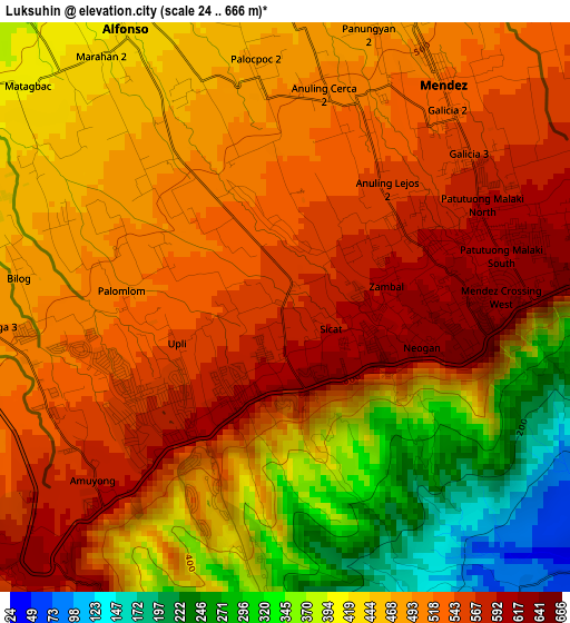
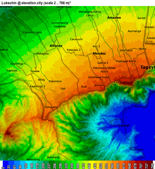
Below is the Elevation map of Luksuhin, which displays elevation range with different colors. Scale of the first map is from 24 to 666 m (79 to 2185 ft) with average elevation of 471.4 meters (=1547 ft) [note 1]
These maps also provides idea of topography and contour of this city, they are displayed at different zoom levels. More info about maps, scale and edge coordinates you can find below images.
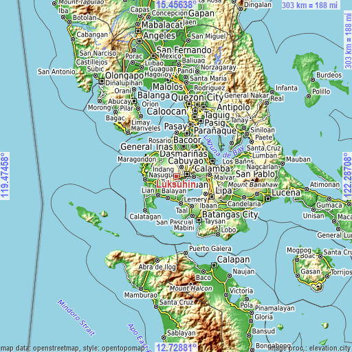
| \ | Map #1 | Map #2 | Topo.Map |
| Scale [m] | 24..666 m | 2..766 m | × |
| Scale [ft] | 79..2185 ft | 7..2513 ft | × |
| Average | 471.4 m = 1547 ft | 378.5 m = 1242 ft | × |
| Width | 9.48 km = 5.9 mi | 18.96 km = 11.8 mi | 303.3 km = 188.5 mi |
| Height | 9.48 km = 5.9 mi | 18.96 km = 11.8 mi | 303.3 km = 188.5 mi |
| ↑Max Latitude | 14.139288° | 14.181898° | 15.45638° |
| Latitude at center | 14.09667° | 14.09667° | 14.09667° |
| ↓Min Latitude | 14.054044° | 14.01141° | 12.72881° |
| ← Min Longitude | 120.836885° | 120.792939° | 119.47458° |
| Longitude center | 120.88083° | 120.88083° | 120.88083° |
| →Max Longitude | 120.924775° | 120.968721° | 122.28708° |
Nearby cities:
Cities around Luksuhin sort by population:
• Tagaytay elevation 663 m
5.7 km,  91°
91°
• Mendez-Nuñez 532 m
4.5 km,  37°
37°
• Laurel 81 m
6.2 km,  137°
137°
• Alfonso 413 m
5.7 km,  329°
329°
• Aga 368 m
8.5 km,  269°
269°
• Mangas 498 m
2.8 km, 326°
• Kaytitinga 450 m
5.7 km,  281°
281°
• Bugaan 30 m
8.7 km, 136°
• Anuling 522 m
3.3 km,  22°
22°
• Taywanak Ilaya 351 m
7.7 km, 331°
• Guyam Malaki 395 m
6.6 km,  341°
341°
• Matagbak 402 m
6.2 km,  307°
307°
Multilingual:
 En español:
Luksuhin elevación 569 m.
 En France:
Luksuhin élévation 569 m.
 Auf Deutsch:
Luksuhin höhe über dem Meeresspiegel ist 569 m.

Sources and notes:
- [note 1] Map square and city borders are not equal. Map elevation data is calculated only from area inside that square.
- [src 1] Elevation data from geonames database provided with same terms of usage.
- [src 2] The elevation map of Luksuhin is generated using elevation data from NASA's 3 arcsec (90m) resolution SRTM data.
- [src 3] Base (background) map © OpenStreetMap contributors tiles are generated by Geofabrik and OpenTopoMap.
Copyright & License:
This Luksuhin Elevation Map is licensed under CC BY-SA. You may reuse any part from this page, if you give a proper credit by linking to this URL:
 More info on terms of use page.