Andili elevation
Andili (Davao, Compostela Valley), Philippines elevation is 108 meters and Andili elevation in feet is 354 ft above sea level [src 1]. Andili is a populated place (feature code) with elevation that is 20 meters (66 ft) bigger than average city elevation in Philippines.
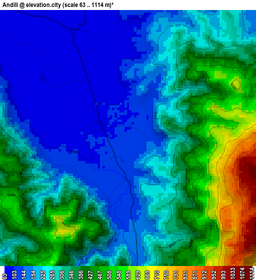
Below is the Elevation map of Andili, which displays elevation range with different colors. Scale of the first map is from 63 to 1114 m (207 to 3655 ft) with average elevation of 299.9 meters (=984 ft) [note 1]
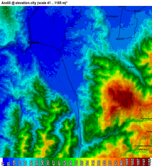
These maps also provides idea of topography and contour of this city, they are displayed at different zoom levels. More info about maps, scale and edge coordinates you can find below images.
| \ | Map #1 | Map #2 | Topo.Map |
| Scale [m] | 63..1114 m | 41..1185 m | × |
| Scale [ft] | 207..3655 ft | 135..3888 ft | × |
| Average | 299.9 m = 984 ft | 344.9 m = 1132 ft | × |
| Width | 9.69 km = 6 mi | 19.38 km = 12 mi | 310 km = 192.6 mi |
| Height | 9.69 km = 6 mi | 19.38 km = 12 mi | 310.1 km = 192.7 mi |
| ↑Max Latitude | 7.505571° | 7.549138° | 8.85398° |
| Latitude at center | 7.462° | 7.462° | 7.462° |
| ↓Min Latitude | 7.418425° | 7.374845° | 6.06557° |
| ← Min Longitude | 125.926155° | 125.882209° | 124.56385° |
| Longitude center | 125.9701° | 125.9701° | 125.9701° |
| →Max Longitude | 126.014045° | 126.057991° | 127.37635° |
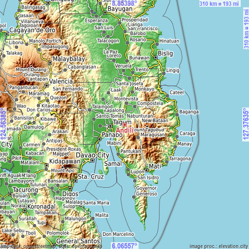
Nearby cities:
Cities around Andili sort by population:
• Magugpo Poblacion elevation 24 m
18.3 km,  264°
264°
• San Mariano 224 m
5.4 km,  37°
37°
• Nabunturan 87 m
16.2 km,  358°
358°
• Maco 11 m
16.9 km,  228°
228°
• Manat 126 m
9.4 km,  33°
33°
• New Bohol 33 m
16.2 km,  294°
294°
• Hiju, Maco 12 m
17.8 km,  241°
241°
• Linoan 90 m
18.2 km,  1°
1°
• Manat 99 m
12.5 km, 25°
• Dumlan 55 m
10.5 km,  248°
248°
• New Sibonga 83 m
11.9 km,  338°
338°
• Mawab 111 m
11.7 km,  7°
7°
Multilingual:
 En español:
Andili elevación 108 m.
 En France:
Andili élévation 108 m.


Sources and notes:
- [note 1] Map square and city borders are not equal. Map elevation data is calculated only from area inside that square.
- [src 1] Elevation data from geonames database provided with same terms of usage.
- [src 2] The elevation map of Andili is generated using elevation data from NASA's 3 arcsec (90m) resolution SRTM data.
- [src 3] Base (background) map © OpenStreetMap contributors tiles are generated by Geofabrik and OpenTopoMap.
Copyright & License:
This Andili Elevation Map is licensed under CC BY-SA. You may reuse any part from this page, if you give a proper credit by linking to this URL:
 More info on terms of use page.