Maco elevation
Maco (Davao, Compostela Valley), Philippines elevation is 11 meters and Maco elevation in feet is 36 ft above sea level [src 1]. Maco is a seat of a third-order administrative division (feature code) with elevation that is 77 meters (253 ft) smaller than average city elevation in Philippines.
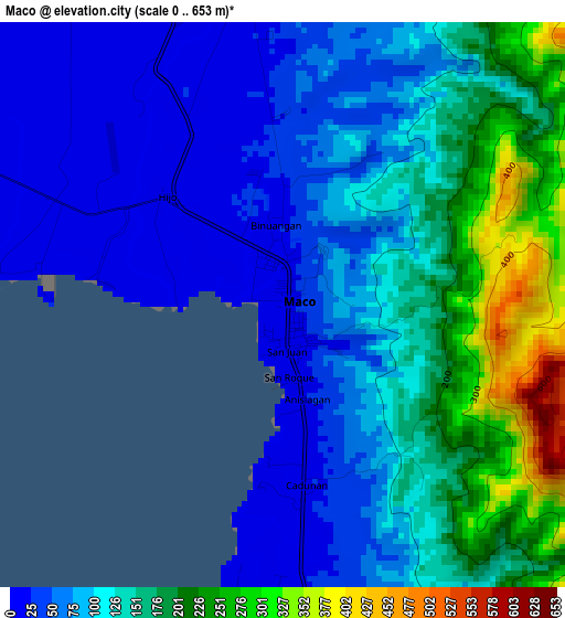
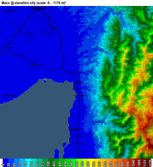
Below is the Elevation map of Maco, which displays elevation range with different colors. Scale of the first map is from 0 to 653 m (0 to 2142 ft) with average elevation of 120.6 meters (=396 ft) [note 1]
These maps also provides idea of topography and contour of this city, they are displayed at different zoom levels. More info about maps, scale and edge coordinates you can find below images.
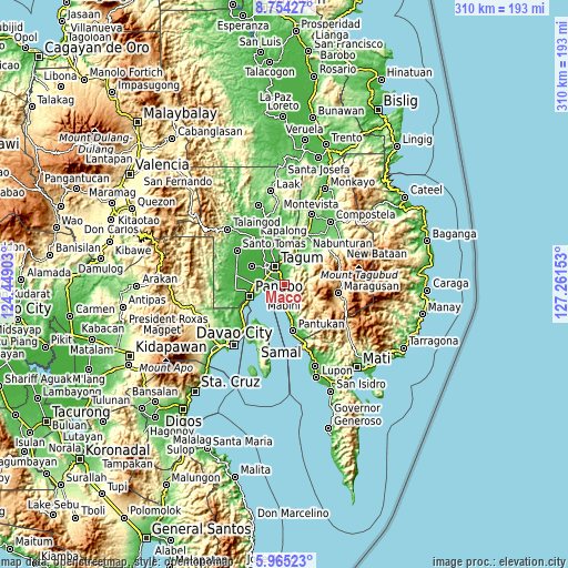
| \ | Map #1 | Map #2 | Topo.Map |
| Scale [m] | 0..653 m | -6..1176 m | × |
| Scale [ft] | 0..2142 ft | -20..3858 ft | × |
| Average | 120.6 m = 396 ft | 223.8 m = 734 ft | × |
| Width | 9.69 km = 6 mi | 19.38 km = 12 mi | 310.1 km = 192.7 mi |
| Height | 9.69 km = 6 mi | 19.38 km = 12 mi | 310.1 km = 192.7 mi |
| ↑Max Latitude | 7.405521° | 7.449097° | 8.75427° |
| Latitude at center | 7.36194° | 7.36194° | 7.36194° |
| ↓Min Latitude | 7.318355° | 7.274765° | 5.96523° |
| ← Min Longitude | 125.811335° | 125.767389° | 124.44903° |
| Longitude center | 125.85528° | 125.85528° | 125.85528° |
| →Max Longitude | 125.899225° | 125.943171° | 127.26153° |
Nearby cities:
Cities around Maco sort by population:
• Magugpo Poblacion elevation 24 m
11 km,  329°
329°
• Corocotan 11 m
10 km,  294°
294°
• Cuambog 12 m
6 km,  187°
187°
• Pandasan 24 m
8.7 km,  181°
181°
• Tagnanan 12 m
8.8 km, 189°
• Tibagon 23 m
14.4 km, 176°
• Bincoñgan 12 m
11.6 km,  272°
272°
• Hiju, Maco 12 m
4 km,  311°
311°
• La Paz 6 m
14.4 km,  249°
249°
• Dumlan 55 m
7.9 km,  21°
21°
• Libuganon 8 m
8.6 km,  260°
260°
• Mabini 18 m
5.6 km, 182°
Multilingual:
 En español:
Maco elevación 11 m.
 En France:
Maco élévation 11 m.


Sources and notes:
- [note 1] Map square and city borders are not equal. Map elevation data is calculated only from area inside that square.
- [src 1] Elevation data from geonames database provided with same terms of usage.
- [src 2] The elevation map of Maco is generated using elevation data from NASA's 3 arcsec (90m) resolution SRTM data.
- [src 3] Base (background) map © OpenStreetMap contributors tiles are generated by Geofabrik and OpenTopoMap.
Copyright & License:
This Maco Elevation Map is licensed under CC BY-SA. You may reuse any part from this page, if you give a proper credit by linking to this URL:
 More info on terms of use page.