Bah-Bah elevation
Bah-Bah (Caraga, Province of Agusan del Sur), Philippines elevation is 43 meters and Bah-Bah elevation in feet is 141 ft above sea level [src 1]. Bah-Bah is a populated place (feature code) with elevation that is 45 meters (148 ft) smaller than average city elevation in Philippines.
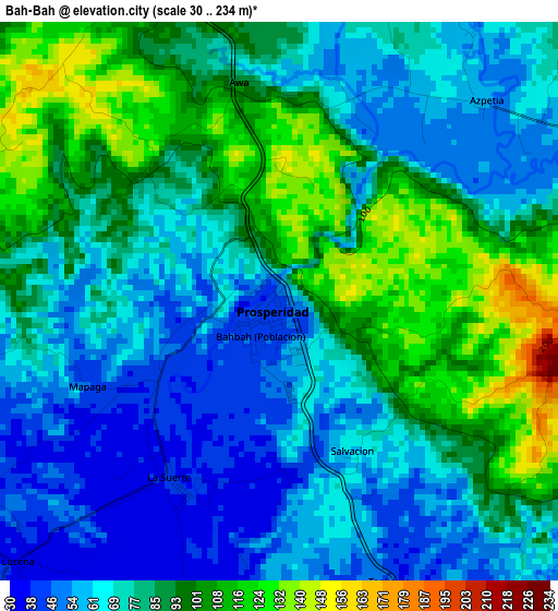
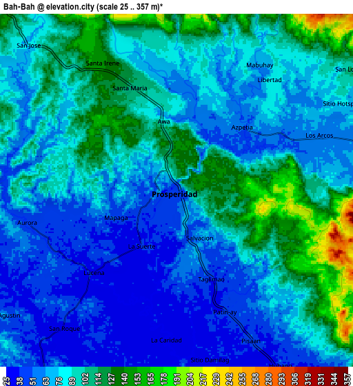
Below is the Elevation map of Bah-Bah, which displays elevation range with different colors. Scale of the first map is from 30 to 234 m (98 to 768 ft) with average elevation of 80.2 meters (=263 ft) [note 1]
These maps also provides idea of topography and contour of this city, they are displayed at different zoom levels. More info about maps, scale and edge coordinates you can find below images.
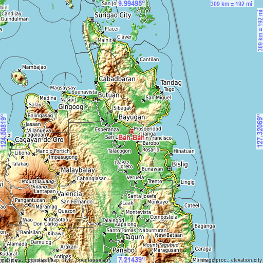
| \ | Map #1 | Map #2 | Topo.Map |
| Scale [m] | 30..234 m | 25..357 m | × |
| Scale [ft] | 98..768 ft | 82..1171 ft | × |
| Average | 80.2 m = 263 ft | 84 m = 276 ft | × |
| Width | 9.66 km = 6 mi | 19.32 km = 12 mi | 309.2 km = 192.1 mi |
| Height | 9.66 km = 6 mi | 19.32 km = 12 mi | 309.2 km = 192.1 mi |
| ↑Max Latitude | 8.650668° | 8.694111° | 9.99495° |
| Latitude at center | 8.60722° | 8.60722° | 8.60722° |
| ↓Min Latitude | 8.563767° | 8.520309° | 7.21439° |
| ← Min Longitude | 125.870495° | 125.826549° | 124.50819° |
| Longitude center | 125.91444° | 125.91444° | 125.91444° |
| →Max Longitude | 125.958385° | 126.002331° | 127.32069° |
Nearby cities:
Cities around Bah-Bah sort by population:
• San Francisco elevation 39 m
8.9 km,  153°
153°
• Lianga 10 m
20 km,  81°
81°
• Patin-ay 38 m
6.8 km,  158°
158°
• Alegria 56 m
15.5 km,  136°
136°
• Lapinigan 40 m
22.1 km, 160°
• Kauswagan 64 m
20.7 km,  240°
240°
• Aurora 41 m
8.6 km,  259°
259°
• Los Arcos 56 m
8.3 km,  70°
70°
• Amaga 50 m
19.1 km,  116°
116°
• Causwagan 24 m
19.5 km,  204°
204°
• Borbon 31 m
13.9 km,  189°
189°
• Prosperidad 39 m
3.6 km,  213°
213°
Multilingual:
 En español:
Bah-Bah elevación 43 m.
 En France:
Bah-Bah élévation 43 m.


Sources and notes:
- [note 1] Map square and city borders are not equal. Map elevation data is calculated only from area inside that square.
- [src 1] Elevation data from geonames database provided with same terms of usage.
- [src 2] The elevation map of Bah-Bah is generated using elevation data from NASA's 3 arcsec (90m) resolution SRTM data.
- [src 3] Base (background) map © OpenStreetMap contributors tiles are generated by Geofabrik and OpenTopoMap.
Copyright & License:
This Bah-Bah Elevation Map is licensed under CC BY-SA. You may reuse any part from this page, if you give a proper credit by linking to this URL:
 More info on terms of use page.