Lapinigan elevation
Lapinigan (Caraga, Province of Agusan del Sur), Philippines elevation is 40 meters and Lapinigan elevation in feet is 131 ft above sea level [src 1]. Lapinigan is a populated place (feature code) with elevation that is 48 meters (157 ft) smaller than average city elevation in Philippines.
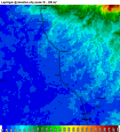
Below is the Elevation map of Lapinigan, which displays elevation range with different colors. Scale of the first map is from 18 to 298 m (59 to 978 ft) with average elevation of 46.8 meters (=154 ft) [note 1]
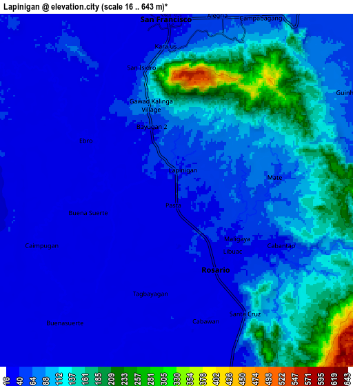
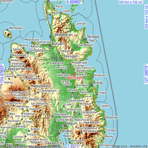
These maps also provides idea of topography and contour of this city, they are displayed at different zoom levels. More info about maps, scale and edge coordinates you can find below images.
| \ | Map #1 | Map #2 | Topo.Map |
| Scale [m] | 18..298 m | 16..643 m | × |
| Scale [ft] | 59..978 ft | 52..2110 ft | × |
| Average | 46.8 m = 154 ft | 77 m = 253 ft | × |
| Width | 9.67 km = 6 mi | 19.33 km = 12 mi | 309.3 km = 192.2 mi |
| Height | 9.67 km = 6 mi | 19.33 km = 12 mi | 309.3 km = 192.2 mi |
| ↑Max Latitude | 8.464029° | 8.507493° | 9.80902° |
| Latitude at center | 8.42056° | 8.42056° | 8.42056° |
| ↓Min Latitude | 8.377086° | 8.333607° | 7.0271° |
| ← Min Longitude | 125.938555° | 125.894609° | 124.57625° |
| Longitude center | 125.9825° | 125.9825° | 125.9825° |
| →Max Longitude | 126.026445° | 126.070391° | 127.38875° |
Nearby cities:
Cities around Lapinigan sort by population:
• Bah-Bah elevation 43 m
22.1 km,  340°
340°
• San Francisco 39 m
13.3 km, 344°
• Tagbina 57 m
21.1 km,  80°
80°
• Barobo 17 m
19.9 km,  50°
50°
• Patin-ay 38 m
15.3 km, 340°
• Alegria 56 m
10.1 km,  18°
18°
• Javier 42 m
13.6 km,  56°
56°
• Amaga 50 m
15.6 km,  38°
38°
• Causwagan 24 m
15.9 km,  280°
280°
• Borbon 31 m
12.1 km,  305°
305°
• Prosperidad 39 m
20.1 km,  331°
331°
• Rosario 27 m
4.4 km,  148°
148°
Multilingual:
 En español:
Lapinigan elevación 40 m.
 En France:
Lapinigan élévation 40 m.
 Auf Deutsch:
Lapinigan höhe über dem Meeresspiegel ist 40 m.

Sources and notes:
- [note 1] Map square and city borders are not equal. Map elevation data is calculated only from area inside that square.
- [src 1] Elevation data from geonames database provided with same terms of usage.
- [src 2] The elevation map of Lapinigan is generated using elevation data from NASA's 3 arcsec (90m) resolution SRTM data.
- [src 3] Base (background) map © OpenStreetMap contributors tiles are generated by Geofabrik and OpenTopoMap.
Copyright & License:
This Lapinigan Elevation Map is licensed under CC BY-SA. You may reuse any part from this page, if you give a proper credit by linking to this URL:
 More info on terms of use page.