Lianga elevation
Lianga (Caraga, Province of Surigao del Sur), Philippines elevation is 10 meters and Lianga elevation in feet is 33 ft above sea level [src 1]. Lianga is a seat of a third-order administrative division (feature code) with elevation that is 78 meters (256 ft) smaller than average city elevation in Philippines.
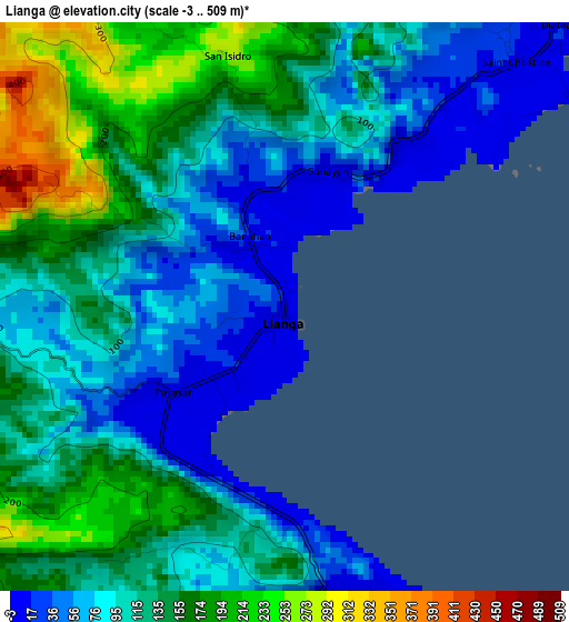
Below is the Elevation map of Lianga, which displays elevation range with different colors. Scale of the first map is from -3 to 509 m (-10 to 1670 ft) with average elevation of 117.4 meters (=385 ft) [note 1]
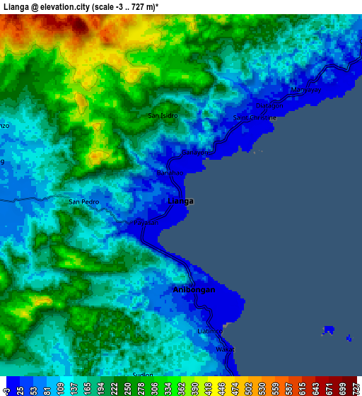
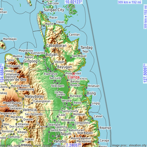
These maps also provides idea of topography and contour of this city, they are displayed at different zoom levels. More info about maps, scale and edge coordinates you can find below images.
| \ | Map #1 | Map #2 | Topo.Map |
| Scale [m] | -3..509 m | -3..727 m | × |
| Scale [ft] | -10..1670 ft | -10..2385 ft | × |
| Average | 117.4 m = 385 ft | 190.6 m = 625 ft | × |
| Width | 9.66 km = 6 mi | 19.32 km = 12 mi | 309.1 km = 192.1 mi |
| Height | 9.66 km = 6 mi | 19.32 km = 12 mi | 309.2 km = 192.1 mi |
| ↑Max Latitude | 8.677055° | 8.720495° | 10.02123° |
| Latitude at center | 8.63361° | 8.63361° | 8.63361° |
| ↓Min Latitude | 8.59016° | 8.546705° | 7.24087° |
| ← Min Longitude | 126.050775° | 126.006829° | 124.68847° |
| Longitude center | 126.09472° | 126.09472° | 126.09472° |
| →Max Longitude | 126.138665° | 126.182611° | 127.50097° |
Nearby cities:
Cities around Lianga sort by population:
• Bah-Bah elevation 43 m
20 km,  261°
261°
• San Francisco 39 m
19.3 km,  235°
235°
• Tagbina 57 m
21.9 km,  157°
157°
• Barobo 17 m
11.3 km, 164°
• Patin-ay 38 m
19.6 km, 241°
• Alegria 56 m
16.8 km,  212°
212°
• Gamut 11 m
19.7 km,  125°
125°
• Unidad 25 m
18.3 km, 126°
• Javier 42 m
16.1 km,  183°
183°
• Los Arcos 56 m
12 km,  269°
269°
• Amaga 50 m
11.7 km,  193°
193°
• Salvacion 15 m
15.3 km,  54°
54°
Multilingual:
 En español:
Lianga elevación 10 m.
 En France:
Lianga élévation 10 m.


Sources and notes:
- [note 1] Map square and city borders are not equal. Map elevation data is calculated only from area inside that square.
- [src 1] Elevation data from geonames database provided with same terms of usage.
- [src 2] The elevation map of Lianga is generated using elevation data from NASA's 3 arcsec (90m) resolution SRTM data.
- [src 3] Base (background) map © OpenStreetMap contributors tiles are generated by Geofabrik and OpenTopoMap.
Copyright & License:
This Lianga Elevation Map is licensed under CC BY-SA. You may reuse any part from this page, if you give a proper credit by linking to this URL:
 More info on terms of use page.