Baler elevation
Baler (Central Luzon, Province of Aurora), Philippines elevation is 12 meters and Baler elevation in feet is 39 ft above sea level [src 1]. Baler is a seat of a third-order administrative division (feature code) with elevation that is 76 meters (249 ft) smaller than average city elevation in Philippines.
Below is the Elevation map of Baler, which displays elevation range with different colors. Scale of the first map is from 0 to 514 m (0 to 1686 ft) with average elevation of 64.5 meters (=212 ft) [note 1]
These maps also provides idea of topography and contour of this city, they are displayed at different zoom levels. More info about maps, scale and edge coordinates you can find below images.
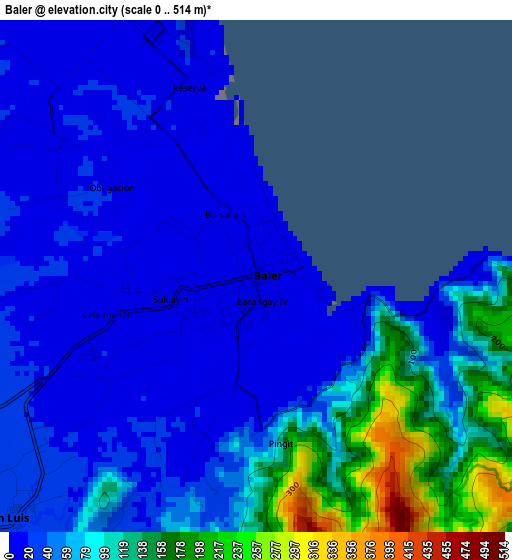
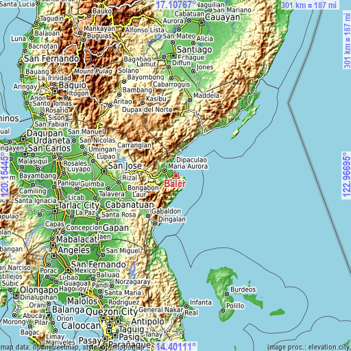
| \ | Map #1 | Topo.Map |
| Scale [m] | 0..514 m | × |
| Scale [ft] | 0..1686 ft | × |
| Average | 64.5 m = 212 ft | × |
| Width | 9.41 km = 5.8 mi | 300.9 km = 187 mi |
| Height | 9.41 km = 5.8 mi | 301 km = 187 mi |
| ↑Max Latitude | 15.801189° | 17.10767° |
| Latitude at center | 15.7589° | 15.7589° |
| ↓Min Latitude | 15.716602° | 14.40111° |
| ← Min Longitude | 121.516755° | 120.15445° |
| Longitude center | 121.5607° | 121.5607° |
| →Max Longitude | 121.604645° | 122.96695° |
Nearby cities:
Cities around Baler sort by population:
• Laur elevation 73 m
44.7 km,  244°
244°
• Dingalan 34 m
44.8 km,  203°
203°
• Gabaldon 137 m
41.6 km,  214°
214°
• Maria Aurora 37 m
10.2 km,  294°
294°
• Pantabangan 278 m
44.9 km,  277°
277°
• Suklayin 12 m
1.1 km,  261°
261°
• Ligaya 113 m
40.4 km,  226°
226°
• Antipolo 87 m
42.7 km,  248°
248°
• General Luna 185 m
41 km,  265°
265°
• Siclong 102 m
41.1 km, 241°
• Bagong-Sikat 123 m
41.2 km,  221°
221°
• San Luis 25 m
6 km, 225°
Multilingual:
 En español:
Baler elevación 12 m.
 En France:
Baler élévation 12 m.


Sources and notes:
- [note 1] Map square and city borders are not equal. Map elevation data is calculated only from area inside that square.
- [src 1] Elevation data from geonames database provided with same terms of usage.
- [src 2] The elevation map of Baler is generated using elevation data from NASA's 3 arcsec (90m) resolution SRTM data.
- [src 3] Base (background) map © OpenStreetMap contributors tiles are generated by Geofabrik and OpenTopoMap.
Copyright & License:
This Baler Elevation Map is licensed under CC BY-SA. You may reuse any part from this page, if you give a proper credit by linking to this URL:
 More info on terms of use page.