Batangas elevation
Batangas (Calabarzon, Province of Batangas), Philippines elevation is 16 meters and Batangas elevation in feet is 52 ft above sea level [src 1]. Batangas is a seat of a second-order administrative division (feature code) with elevation that is 72 meters (236 ft) smaller than average city elevation in Philippines.
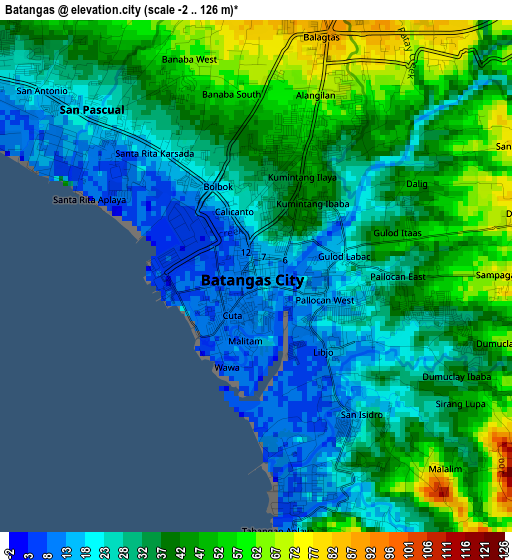
Below is the Elevation map of Batangas, which displays elevation range with different colors. Scale of the first map is from -2 to 126 m (-7 to 413 ft) with average elevation of 36.3 meters (=119 ft) [note 1]
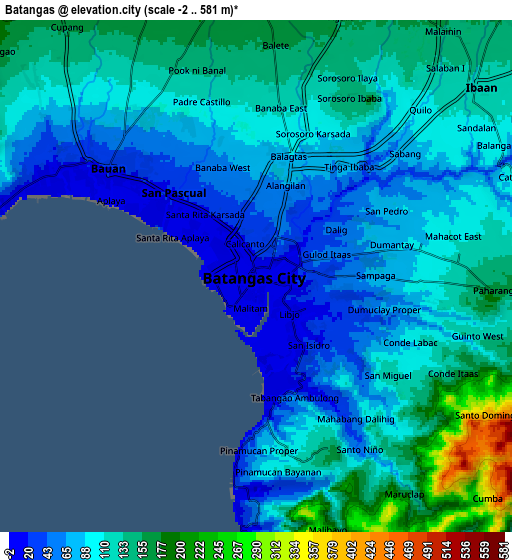
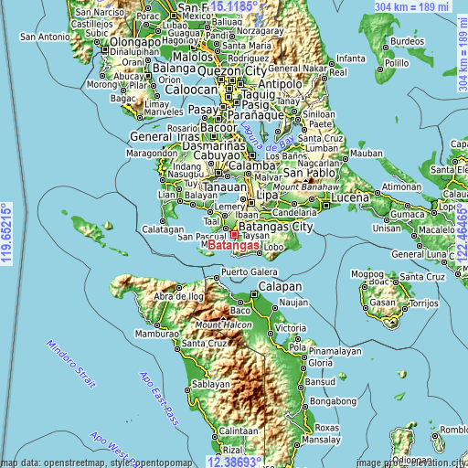
These maps also provides idea of topography and contour of this city, they are displayed at different zoom levels. More info about maps, scale and edge coordinates you can find below images.
| \ | Map #1 | Map #2 | Topo.Map |
| Scale [m] | -2..126 m | -2..581 m | × |
| Scale [ft] | -7..413 ft | -7..1906 ft | × |
| Average | 36.3 m = 119 ft | 107 m = 351 ft | × |
| Width | 9.49 km = 5.9 mi | 18.98 km = 11.8 mi | 303.7 km = 188.7 mi |
| Height | 9.49 km = 5.9 mi | 18.98 km = 11.8 mi | 303.7 km = 188.7 mi |
| ↑Max Latitude | 13.799381° | 13.842054° | 15.1185° |
| Latitude at center | 13.7567° | 13.7567° | 13.7567° |
| ↓Min Latitude | 13.714011° | 13.671315° | 12.38693° |
| ← Min Longitude | 121.014455° | 120.970509° | 119.65215° |
| Longitude center | 121.0584° | 121.0584° | 121.0584° |
| →Max Longitude | 121.102345° | 121.146291° | 122.46465° |
Nearby cities:
Cities around Batangas sort by population:
• San Pascual elevation 81 m
7.2 km,  326°
326°
• Bauan 20 m
6.6 km,  305°
305°
• Santa Rita Aplaya 9 m
3 km,  303°
303°
• Ibaan 122 m
10.5 km,  49°
49°
• Bolo 21 m
9.1 km,  294°
294°
• Santa Clara 11 m
0.4 km,  145°
145°
• Wawa 8 m
1.9 km,  197°
197°
• Bukal 151 m
9.7 km,  23°
23°
• Sinala 92 m
10.6 km, 301°
• Haligue 369 m
11.8 km, 147°
• Inicbulan 118 m
10.8 km, 311°
• Santo Niño 47 m
7.3 km, 147°
Multilingual:
 En español:
Batangas elevación 16 m.
 En France:
Batangas élévation 16 m.


Sources and notes:
- [note 1] Map square and city borders are not equal. Map elevation data is calculated only from area inside that square.
- [src 1] Elevation data from geonames database provided with same terms of usage.
- [src 2] The elevation map of Batangas is generated using elevation data from NASA's 3 arcsec (90m) resolution SRTM data.
- [src 3] Base (background) map © OpenStreetMap contributors tiles are generated by Geofabrik and OpenTopoMap.
Copyright & License:
This Batangas Elevation Map is licensed under CC BY-SA. You may reuse any part from this page, if you give a proper credit by linking to this URL:
 More info on terms of use page.