Bolo elevation
Bolo (Calabarzon, Province of Batangas), Philippines elevation is 21 meters and Bolo elevation in feet is 69 ft above sea level [src 1]. Bolo is a populated place (feature code) with elevation that is 67 meters (220 ft) smaller than average city elevation in Philippines.
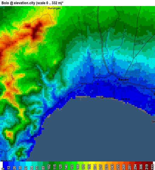
Below is the Elevation map of Bolo, which displays elevation range with different colors. Scale of the first map is from 0 to 332 m (0 to 1089 ft) with average elevation of 102.9 meters (=338 ft) [note 1]
These maps also provides idea of topography and contour of this city, they are displayed at different zoom levels. More info about maps, scale and edge coordinates you can find below images.
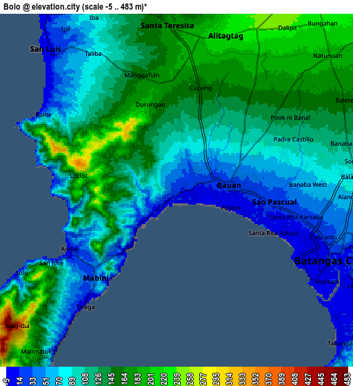
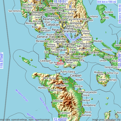
| \ | Map #1 | Map #2 | Topo.Map |
| Scale [m] | 0..332 m | -5..483 m | × |
| Scale [ft] | 0..1089 ft | -16..1585 ft | × |
| Average | 102.9 m = 338 ft | 117.4 m = 385 ft | × |
| Width | 9.49 km = 5.9 mi | 18.98 km = 11.8 mi | 303.7 km = 188.7 mi |
| Height | 9.49 km = 5.9 mi | 18.98 km = 11.8 mi | 303.7 km = 188.7 mi |
| ↑Max Latitude | 13.832585° | 13.875252° | 15.15151° |
| Latitude at center | 13.78991° | 13.78991° | 13.78991° |
| ↓Min Latitude | 13.747227° | 13.704537° | 12.42032° |
| ← Min Longitude | 120.937785° | 120.893839° | 119.57548° |
| Longitude center | 120.98173° | 120.98173° | 120.98173° |
| →Max Longitude | 121.025675° | 121.069621° | 122.38798° |
Nearby cities:
Cities around Bolo sort by population:
• San Pascual elevation 81 m
4.9 km,  62°
62°
• Bauan 20 m
2.9 km,  86°
86°
• Santa Rita Aplaya 9 m
6.1 km,  109°
109°
• Mozon 191 m
7 km,  6°
6°
• Alitagtag 217 m
8.6 km,  16°
16°
• Talaga 9 m
7.7 km,  219°
219°
• Santa Teresita 176 m
8.5 km,  359°
359°
• Sinala 92 m
1.9 km,  336°
336°
• Mabini 37 m
6 km,  227°
227°
• Inicbulan 118 m
3.4 km,  3°
3°
• Calumpang 178 m
5.9 km,  353°
353°
• San Jose 98 m
7.7 km,  333°
333°
Multilingual:
 En español:
Bolo elevación 21 m.
 En France:
Bolo élévation 21 m.


Sources and notes:
- [note 1] Map square and city borders are not equal. Map elevation data is calculated only from area inside that square.
- [src 1] Elevation data from geonames database provided with same terms of usage.
- [src 2] The elevation map of Bolo is generated using elevation data from NASA's 3 arcsec (90m) resolution SRTM data.
- [src 3] Base (background) map © OpenStreetMap contributors tiles are generated by Geofabrik and OpenTopoMap.
Copyright & License:
This Bolo Elevation Map is licensed under CC BY-SA. You may reuse any part from this page, if you give a proper credit by linking to this URL:
 More info on terms of use page.