Bucloc elevation
Bucloc (Cordillera, Province of Abra), Philippines elevation is 341 meters and Bucloc elevation in feet is 1119 ft above sea level [src 1]. Bucloc is a seat of a third-order administrative division (feature code) with elevation that is 253 meters (830 ft) bigger than average city elevation in Philippines.
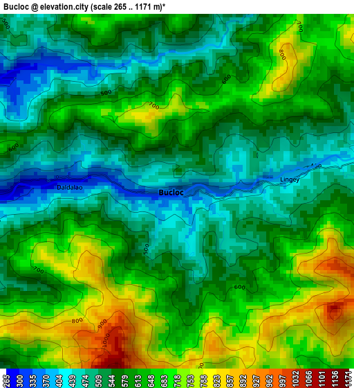
Below is the Elevation map of Bucloc, which displays elevation range with different colors. Scale of the first map is from 265 to 1171 m (869 to 3842 ft) with average elevation of 599.6 meters (=1967 ft) [note 1]
These maps also provides idea of topography and contour of this city, they are displayed at different zoom levels. More info about maps, scale and edge coordinates you can find below images.
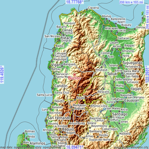
| \ | Map #1 | Topo.Map |
| Scale [m] | 265..1171 m | × |
| Scale [ft] | 869..3842 ft | × |
| Average | 599.6 m = 1967 ft | × |
| Width | 9.32 km = 5.8 mi | 298.3 km = 185.4 mi |
| Height | 9.32 km = 5.8 mi | 298.3 km = 185.4 mi |
| ↑Max Latitude | 17.48305° | 18.77768° |
| Latitude at center | 17.44113° | 17.44113° |
| ↓Min Latitude | 17.3992° | 16.09471° |
| ← Min Longitude | 120.814905° | 119.4526° |
| Longitude center | 120.85885° | 120.85885° |
| →Max Longitude | 120.902795° | 122.2651° |
Nearby cities:
Cities around Bucloc sort by population:
• San Ramon elevation 131 m
16.3 km,  259°
259°
• Bantay 183 m
10.7 km,  268°
268°
• Peñarrubia 94 m
25.9 km,  302°
302°
• Villaviciosa 178 m
24.7 km, 269°
• Tubo 333 m
23.4 km,  214°
214°
• Lagangilang 74 m
23.1 km,  325°
325°
• Luba 175 m
22.2 km,  231°
231°
• Licuan 377 m
19.3 km,  14°
14°
• Bucay 96 m
18.5 km,  306°
306°
• Manabo 125 m
16.3 km, 266°
• Boliney 255 m
9 km,  245°
245°
• Daguioman 444 m
6.1 km,  79°
79°
Multilingual:
 En español:
Bucloc elevación 341 m.
 En France:
Bucloc élévation 341 m.


Sources and notes:
- [note 1] Map square and city borders are not equal. Map elevation data is calculated only from area inside that square.
- [src 1] Elevation data from geonames database provided with same terms of usage.
- [src 2] The elevation map of Bucloc is generated using elevation data from NASA's 3 arcsec (90m) resolution SRTM data.
- [src 3] Base (background) map © OpenStreetMap contributors tiles are generated by Geofabrik and OpenTopoMap.
Copyright & License:
This Bucloc Elevation Map is licensed under CC BY-SA. You may reuse any part from this page, if you give a proper credit by linking to this URL:
 More info on terms of use page.