Luba elevation
Luba (Cordillera, Province of Abra), Philippines elevation is 175 meters and Luba elevation in feet is 574 ft above sea level [src 1]. Luba is a seat of a third-order administrative division (feature code) with elevation that is 87 meters (285 ft) bigger than average city elevation in Philippines.
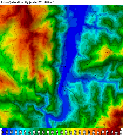
Below is the Elevation map of Luba, which displays elevation range with different colors. Scale of the first map is from 137 to 848 m (449 to 2782 ft) with average elevation of 414.9 meters (=1361 ft) [note 1]
These maps also provides idea of topography and contour of this city, they are displayed at different zoom levels. More info about maps, scale and edge coordinates you can find below images.
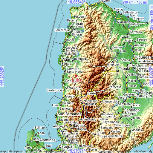
| \ | Map #1 | Topo.Map |
| Scale [m] | 137..848 m | × |
| Scale [ft] | 449..2782 ft | × |
| Average | 414.9 m = 1361 ft | × |
| Width | 9.33 km = 5.8 mi | 298.5 km = 185.5 mi |
| Height | 9.33 km = 5.8 mi | 298.5 km = 185.5 mi |
| ↑Max Latitude | 17.359948° | 18.65549° |
| Latitude at center | 17.318° | 17.318° |
| ↓Min Latitude | 17.276042° | 15.97071° |
| ← Min Longitude | 120.650555° | 119.28825° |
| Longitude center | 120.6945° | 120.6945° |
| →Max Longitude | 120.738445° | 122.10075° |
Nearby cities:
Cities around Luba sort by population:
• San Ramon elevation 131 m
10.7 km,  7°
7°
• Bantay 183 m
14.9 km,  26°
26°
• Burgos 21 m
21.2 km,  274°
274°
• Lidlidda 47 m
19.2 km,  253°
253°
• San Isidro 139 m
19 km,  329°
329°
• Quirino 317 m
18.2 km,  188°
188°
• Villaviciosa 178 m
15.2 km, 331°
• Pilar 332 m
15.2 km,  316°
316°
• Boliney 255 m
13.6 km,  42°
42°
• San Emilio 479 m
13.5 km,  220°
220°
• Manabo 125 m
12.9 km, 5°
• Tubo 333 m
7.2 km,  142°
142°
Multilingual:
 En español:
Luba elevación 175 m.
 En France:
Luba élévation 175 m.


Sources and notes:
- [note 1] Map square and city borders are not equal. Map elevation data is calculated only from area inside that square.
- [src 1] Elevation data from geonames database provided with same terms of usage.
- [src 2] The elevation map of Luba is generated using elevation data from NASA's 3 arcsec (90m) resolution SRTM data.
- [src 3] Base (background) map © OpenStreetMap contributors tiles are generated by Geofabrik and OpenTopoMap.
Copyright & License:
This Luba Elevation Map is licensed under CC BY-SA. You may reuse any part from this page, if you give a proper credit by linking to this URL:
 More info on terms of use page.