Quirino elevation
Quirino (Ilocos, Province of Ilocos Sur), Philippines elevation is 317 meters and Quirino elevation in feet is 1040 ft above sea level [src 1]. Quirino is a seat of a third-order administrative division (feature code) with elevation that is 229 meters (751 ft) bigger than average city elevation in Philippines.
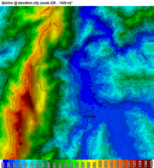
Below is the Elevation map of Quirino, which displays elevation range with different colors. Scale of the first map is from 239 to 1430 m (784 to 4692 ft) with average elevation of 573.7 meters (=1882 ft) [note 1]
These maps also provides idea of topography and contour of this city, they are displayed at different zoom levels. More info about maps, scale and edge coordinates you can find below images.
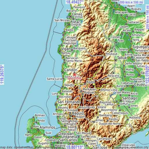
| \ | Map #1 | Topo.Map |
| Scale [m] | 239..1430 m | × |
| Scale [ft] | 784..4692 ft | × |
| Average | 573.7 m = 1882 ft | × |
| Width | 9.34 km = 5.8 mi | 298.8 km = 185.7 mi |
| Height | 9.34 km = 5.8 mi | 298.8 km = 185.7 mi |
| ↑Max Latitude | 17.197545° | 18.49427° |
| Latitude at center | 17.15556° | 17.15556° |
| ↓Min Latitude | 17.113565° | 15.80713° |
| ← Min Longitude | 120.626055° | 119.26375° |
| Longitude center | 120.67° | 120.67° |
| →Max Longitude | 120.713945° | 122.07625° |
Nearby cities:
Cities around Quirino sort by population:
• Cervantes elevation 502 m
19.6 km,  159°
159°
• Sigay 470 m
10.9 km,  222°
222°
• Besao 1393 m
21.1 km,  108°
108°
• Allangigan Primero 27 m
19 km,  276°
276°
• Banayoyo 50 m
21.6 km,  293°
293°
• Galimuyod 44 m
21.3 km, 278°
• Lidlidda 47 m
20.2 km,  308°
308°
• Luba 175 m
18.2 km,  8°
8°
• Tubo 333 m
14.2 km,  29°
29°
• Salcedo 88 m
13.9 km,  269°
269°
• San Emilio 479 m
10 km,  321°
321°
• Gregorio del Pilar 342 m
6.8 km,  245°
245°
Multilingual:
 En español:
Quirino elevación 317 m.
 En France:
Quirino élévation 317 m.


Sources and notes:
- [note 1] Map square and city borders are not equal. Map elevation data is calculated only from area inside that square.
- [src 1] Elevation data from geonames database provided with same terms of usage.
- [src 2] The elevation map of Quirino is generated using elevation data from NASA's 3 arcsec (90m) resolution SRTM data.
- [src 3] Base (background) map © OpenStreetMap contributors tiles are generated by Geofabrik and OpenTopoMap.
Copyright & License:
This Quirino Elevation Map is licensed under CC BY-SA. You may reuse any part from this page, if you give a proper credit by linking to this URL:
 More info on terms of use page.