Da-an Sur elevation
Da-an Sur (Western Visayas, Province of Capiz), Philippines elevation is 268 meters and Da-an Sur elevation in feet is 879 ft above sea level [src 1]. Da-an Sur is a populated place (feature code) with elevation that is 180 meters (591 ft) bigger than average city elevation in Philippines.
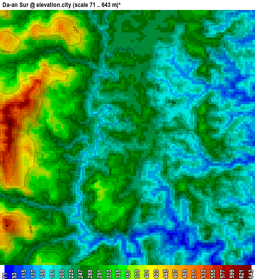
Below is the Elevation map of Da-an Sur, which displays elevation range with different colors. Scale of the first map is from 71 to 643 m (233 to 2110 ft) with average elevation of 255 meters (=837 ft) [note 1]
These maps also provides idea of topography and contour of this city, they are displayed at different zoom levels. More info about maps, scale and edge coordinates you can find below images.
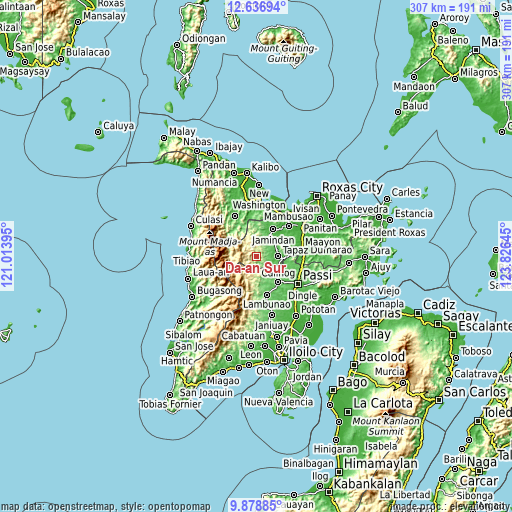
| \ | Map #1 | Topo.Map |
| Scale [m] | 71..643 m | × |
| Scale [ft] | 233..2110 ft | × |
| Average | 255 m = 837 ft | × |
| Width | 9.58 km = 6 mi | 306.7 km = 190.6 mi |
| Height | 9.58 km = 6 mi | 306.7 km = 190.6 mi |
| ↑Max Latitude | 11.304296° | 12.63694° |
| Latitude at center | 11.2612° | 11.2612° |
| ↓Min Latitude | 11.218098° | 9.87885° |
| ← Min Longitude | 122.376255° | 121.01395° |
| Longitude center | 122.4202° | 122.4202° |
| →Max Longitude | 122.464145° | 123.82645° |
Nearby cities:
Cities around Da-an Sur sort by population:
• Jaena elevation 176 m
17.4 km,  352°
352°
• Bingawan 81 m
16.3 km,  101°
101°
• Duran 43 m
18.7 km,  89°
89°
• Manika 105 m
20.9 km,  312°
312°
• Alibunan 114 m
13.4 km,  161°
161°
• San Nicolas 53 m
12.6 km,  58°
58°
• Tapas 43 m
12.7 km, 89°
• Ag-ambulong 52 m
15.4 km,  39°
39°
• Candelaria 44 m
11.6 km,  74°
74°
• Jamindan 36 m
17.7 km,  28°
28°
• San Miguel 75 m
14.3 km,  111°
111°
• Badlan 72 m
17.2 km,  140°
140°
Multilingual:
 En español:
Da-an Sur elevación 268 m.
 En France:
Da-an Sur élévation 268 m.
 Auf Deutsch:
Da-an Sur höhe über dem Meeresspiegel ist 268 m.

Sources and notes:
- [note 1] Map square and city borders are not equal. Map elevation data is calculated only from area inside that square.
- [src 1] Elevation data from geonames database provided with same terms of usage.
- [src 2] The elevation map of Da-an Sur is generated using elevation data from NASA's 3 arcsec (90m) resolution SRTM data.
- [src 3] Base (background) map © OpenStreetMap contributors tiles are generated by Geofabrik and OpenTopoMap.
Copyright & License:
This Da-an Sur Elevation Map is licensed under CC BY-SA. You may reuse any part from this page, if you give a proper credit by linking to this URL:
 More info on terms of use page.