Davao elevation
Davao, Philippines elevation is 13 meters and Davao elevation in feet is 43 ft above sea level [src 1]. Davao is a seat of a first-order administrative division (feature code) with elevation that is 75 meters (246 ft) smaller than average city elevation in Philippines.
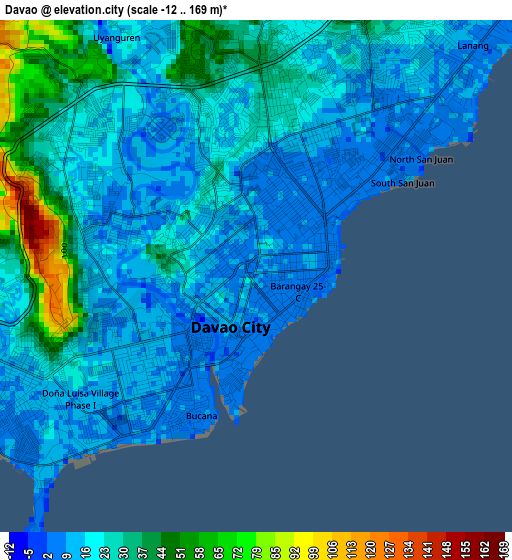
Below is the Elevation map of Davao, which displays elevation range with different colors. Scale of the first map is from -12 to 169 m (-39 to 554 ft) with average elevation of 22.1 meters (=73 ft) [note 1]
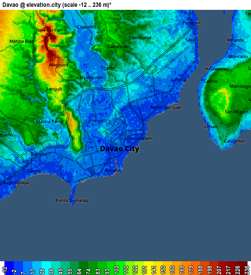
These maps also provides idea of topography and contour of this city, they are displayed at different zoom levels. More info about maps, scale and edge coordinates you can find below images.
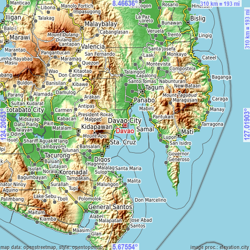
| \ | Map #1 | Map #2 | Topo.Map |
| Scale [m] | -12..169 m | -12..236 m | × |
| Scale [ft] | -39..554 ft | -39..774 ft | × |
| Average | 22.1 m = 73 ft | 52.3 m = 172 ft | × |
| Width | 9.7 km = 6 mi | 19.4 km = 12.1 mi | 310.3 km = 192.8 mi |
| Height | 9.7 km = 6 mi | 19.4 km = 12.1 mi | 310.3 km = 192.8 mi |
| ↑Max Latitude | 7.116669° | 7.160274° | 8.46636° |
| Latitude at center | 7.07306° | 7.07306° | 7.07306° |
| ↓Min Latitude | 7.029447° | 6.98583° | 5.67554° |
| ← Min Longitude | 125.568835° | 125.524889° | 124.20653° |
| Longitude center | 125.61278° | 125.61278° | 125.61278° |
| →Max Longitude | 125.656725° | 125.700671° | 127.01903° |
Nearby cities:
Cities around Davao sort by population:
• Samal elevation 8 m
10.5 km,  89°
89°
• Biao 189 m
14.2 km,  314°
314°
• Bato 99 m
15.8 km,  257°
257°
• Mambago 86 m
9.7 km,  68°
68°
• Mahayag 118 m
16 km,  2°
2°
• Ula 210 m
14.8 km,  296°
296°
• Tambo 60 m
13.3 km,  45°
45°
• San Antonio 230 m
14.9 km, 69°
• Cogon 50 m
14.4 km, 53°
• Camudmud 5 m
14.5 km,  37°
37°
• Limao 27 m
6.7 km,  84°
84°
• Babak 8 m
10.8 km, 49°
Multilingual:
 En español:
Davao elevación 13 m.
 En France:
Davao élévation 13 m.


Sources and notes:
- [note 1] Map square and city borders are not equal. Map elevation data is calculated only from area inside that square.
- [src 1] Elevation data from geonames database provided with same terms of usage.
- [src 2] The elevation map of Davao is generated using elevation data from NASA's 3 arcsec (90m) resolution SRTM data.
- [src 3] Base (background) map © OpenStreetMap contributors tiles are generated by Geofabrik and OpenTopoMap.
Copyright & License:
This Davao Elevation Map is licensed under CC BY-SA. You may reuse any part from this page, if you give a proper credit by linking to this URL:
 More info on terms of use page.