Bato elevation
Bato (Davao, Province of Davao del Sur), Philippines elevation is 99 meters and Bato elevation in feet is 325 ft above sea level [src 1]. Bato is a populated place (feature code) with elevation that is 11 meters (36 ft) bigger than average city elevation in Philippines.
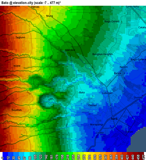
Below is the Elevation map of Bato, which displays elevation range with different colors. Scale of the first map is from -7 to 477 m (-23 to 1565 ft) with average elevation of 170.5 meters (=559 ft) [note 1]
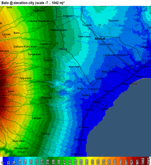
These maps also provides idea of topography and contour of this city, they are displayed at different zoom levels. More info about maps, scale and edge coordinates you can find below images.
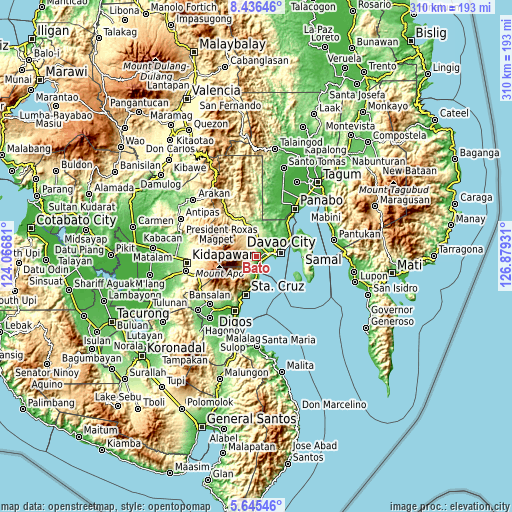
| \ | Map #1 | Map #2 | Topo.Map |
| Scale [m] | -7..477 m | -7..1042 m | × |
| Scale [ft] | -23..1565 ft | -23..3419 ft | × |
| Average | 170.5 m = 559 ft | 297 m = 974 ft | × |
| Width | 9.7 km = 6 mi | 19.4 km = 12.1 mi | 310.3 km = 192.8 mi |
| Height | 9.7 km = 6 mi | 19.4 km = 12.1 mi | 310.4 km = 192.9 mi |
| ↑Max Latitude | 7.086672° | 7.130279° | 8.43646° |
| Latitude at center | 7.04306° | 7.04306° | 7.04306° |
| ↓Min Latitude | 6.999444° | 6.955824° | 5.64546° |
| ← Min Longitude | 125.429115° | 125.385169° | 124.06681° |
| Longitude center | 125.47306° | 125.47306° | 125.47306° |
| →Max Longitude | 125.517005° | 125.560951° | 126.87931° |
Nearby cities:
Cities around Bato sort by population:
• Davao elevation 13 m
15.8 km,  77°
77°
• Biao 189 m
14.4 km,  21°
21°
• Astorga 45 m
15.2 km,  187°
187°
• Sibulan 63 m
12.2 km, 185°
• Wañgan 279 m
13.3 km,  346°
346°
• Baracatan 443 m
10.5 km,  216°
216°
• Tamayong 698 m
14.4 km,  314°
314°
• Inawayan 30 m
9.1 km,  179°
179°
• Sirib 482 m
12.4 km,  324°
324°
• Malagos 358 m
16.7 km,  340°
340°
• Tagakpan 415 m
9.1 km,  328°
328°
• Ula 210 m
10.1 km,  12°
12°
Multilingual:
 En español:
Bato elevación 99 m.
 En France:
Bato élévation 99 m.


Sources and notes:
- [note 1] Map square and city borders are not equal. Map elevation data is calculated only from area inside that square.
- [src 1] Elevation data from geonames database provided with same terms of usage.
- [src 2] The elevation map of Bato is generated using elevation data from NASA's 3 arcsec (90m) resolution SRTM data.
- [src 3] Base (background) map © OpenStreetMap contributors tiles are generated by Geofabrik and OpenTopoMap.
Copyright & License:
This Bato Elevation Map is licensed under CC BY-SA. You may reuse any part from this page, if you give a proper credit by linking to this URL:
 More info on terms of use page.