Samal elevation
Samal (Davao, Province of Davao del Norte), Philippines elevation is 8 meters and Samal elevation in feet is 26 ft above sea level [src 1]. Samal is a seat of a third-order administrative division (feature code) with elevation that is 80 meters (262 ft) smaller than average city elevation in Philippines.
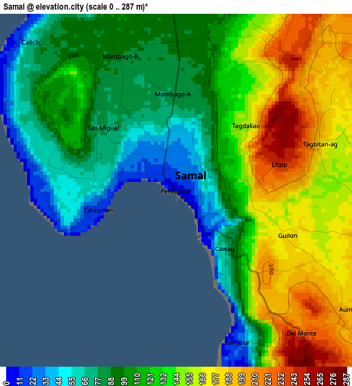
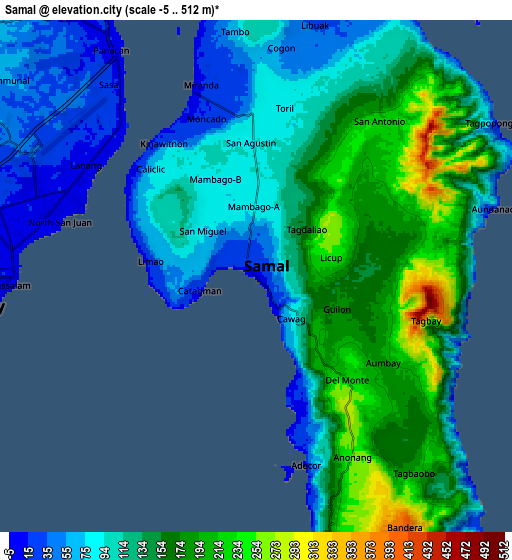
Below is the Elevation map of Samal, which displays elevation range with different colors. Scale of the first map is from 0 to 287 m (0 to 942 ft) with average elevation of 125 meters (=410 ft) [note 1]
These maps also provides idea of topography and contour of this city, they are displayed at different zoom levels. More info about maps, scale and edge coordinates you can find below images.
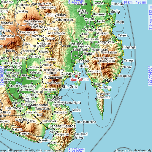
| \ | Map #1 | Map #2 | Topo.Map |
| Scale [m] | 0..287 m | -5..512 m | × |
| Scale [ft] | 0..942 ft | -16..1680 ft | × |
| Average | 125 m = 410 ft | 128.2 m = 421 ft | × |
| Width | 9.7 km = 6 mi | 19.4 km = 12.1 mi | 310.3 km = 192.8 mi |
| Height | 9.7 km = 6 mi | 19.4 km = 12.1 mi | 310.3 km = 192.8 mi |
| ↑Max Latitude | 7.118049° | 7.161653° | 8.46774° |
| Latitude at center | 7.07444° | 7.07444° | 7.07444° |
| ↓Min Latitude | 7.030827° | 6.98721° | 5.67692° |
| ← Min Longitude | 125.664385° | 125.620439° | 124.30208° |
| Longitude center | 125.70833° | 125.70833° | 125.70833° |
| →Max Longitude | 125.752275° | 125.796221° | 127.11458° |
Nearby cities:
Cities around Samal sort by population:
• Davao elevation 13 m
10.5 km,  269°
269°
• Aumbay 93 m
8.9 km,  69°
69°
• Mambago 86 m
3.8 km,  336°
336°
• Mahayag 118 m
18.6 km,  328°
328°
• Tambo 60 m
9.2 km,  353°
353°
• San Antonio 230 m
6.1 km,  34°
34°
• Cogon 50 m
8.6 km,  6°
6°
• Camudmud 5 m
11.4 km, 351°
• San Remigio 39 m
18.4 km,  156°
156°
• Limao 27 m
3.9 km,  277°
277°
• Kaputian 32 m
12.2 km,  170°
170°
• Babak 8 m
7.3 km, 341°
Multilingual:
 En español:
Sámal elevación 8 m.
 En France:
Samal élévation 8 m.
 Auf Deutsch:
Island Garden City of Samal höhe über dem Meeresspiegel ist 8 m.

Sources and notes:
- [note 1] Map square and city borders are not equal. Map elevation data is calculated only from area inside that square.
- [src 1] Elevation data from geonames database provided with same terms of usage.
- [src 2] The elevation map of Samal is generated using elevation data from NASA's 3 arcsec (90m) resolution SRTM data.
- [src 3] Base (background) map © OpenStreetMap contributors tiles are generated by Geofabrik and OpenTopoMap.
Copyright & License:
This Samal Elevation Map is licensed under CC BY-SA. You may reuse any part from this page, if you give a proper credit by linking to this URL:
 More info on terms of use page.