Jayubó elevation
Jayubó (Western Visayas, Province of Iloilo), Philippines elevation is 391 meters and Jayubó elevation in feet is 1283 ft above sea level [src 1]. Jayubó is a populated place (feature code) with elevation that is 303 meters (994 ft) bigger than average city elevation in Philippines.
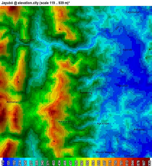
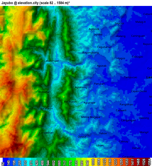
Below is the Elevation map of Jayubó, which displays elevation range with different colors. Scale of the first map is from 119 to 939 m (390 to 3081 ft) with average elevation of 381.5 meters (=1252 ft) [note 1]
These maps also provides idea of topography and contour of this city, they are displayed at different zoom levels. More info about maps, scale and edge coordinates you can find below images.
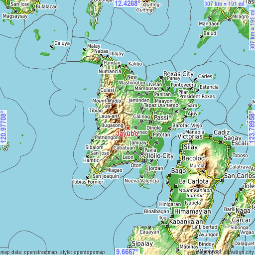
| \ | Map #1 | Map #2 | Topo.Map |
| Scale [m] | 119..939 m | 82..1584 m | × |
| Scale [ft] | 390..3081 ft | 269..5197 ft | × |
| Average | 381.5 m = 1252 ft | 475.3 m = 1559 ft | × |
| Width | 9.59 km = 6 mi | 19.18 km = 11.9 mi | 306.9 km = 190.7 mi |
| Height | 9.59 km = 6 mi | 19.18 km = 11.9 mi | 306.9 km = 190.7 mi |
| ↑Max Latitude | 11.093127° | 11.136248° | 12.4268° |
| Latitude at center | 11.05° | 11.05° | 11.05° |
| ↓Min Latitude | 11.006866° | 10.963726° | 9.6667° |
| ← Min Longitude | 122.339385° | 122.295439° | 120.97708° |
| Longitude center | 122.38333° | 122.38333° | 122.38333° |
| →Max Longitude | 122.427275° | 122.471221° | 123.78958° |
Nearby cities:
Cities around Jayubó sort by population:
• Janiuay elevation 66 m
17.5 km,  129°
129°
• Cabatuan 60 m
22 km,  149°
149°
• Calinog 51 m
21.3 km,  69°
69°
• Lambunao 177 m
10.1 km,  86°
86°
• Maasin 84 m
18.4 km,  162°
162°
• Maribong 56 m
17.3 km, 71°
• Alibunan 114 m
13.5 km,  37°
37°
• Binabaan 81 m
15.5 km,  102°
102°
• Gines-Patay 131 m
17.5 km,  136°
136°
• Quinagaringan 52 m
23.7 km, 70°
• Badlan 72 m
18 km,  55°
55°
• Badiangan 90 m
13.7 km,  111°
111°
Multilingual:
 En español:
Jayubó elevación 391 m.
 En France:
Jayubó élévation 391 m.


Sources and notes:
- [note 1] Map square and city borders are not equal. Map elevation data is calculated only from area inside that square.
- [src 1] Elevation data from geonames database provided with same terms of usage.
- [src 2] The elevation map of Jayubó is generated using elevation data from NASA's 3 arcsec (90m) resolution SRTM data.
- [src 3] Base (background) map © OpenStreetMap contributors tiles are generated by Geofabrik and OpenTopoMap.
Copyright & License:
This Jayubó Elevation Map is licensed under CC BY-SA. You may reuse any part from this page, if you give a proper credit by linking to this URL:
 More info on terms of use page.