Lambunao elevation
Lambunao (Western Visayas, Province of Iloilo), Philippines elevation is 177 meters and Lambunao elevation in feet is 581 ft above sea level [src 1]. Lambunao is a seat of a third-order administrative division (feature code) with elevation that is 89 meters (292 ft) bigger than average city elevation in Philippines.
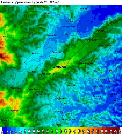
Below is the Elevation map of Lambunao, which displays elevation range with different colors. Scale of the first map is from 62 to 272 m (203 to 892 ft) with average elevation of 114.6 meters (=376 ft) [note 1]
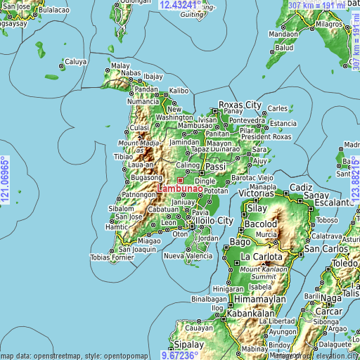
These maps also provides idea of topography and contour of this city, they are displayed at different zoom levels. More info about maps, scale and edge coordinates you can find below images.
| \ | Map #1 | Map #2 | Topo.Map |
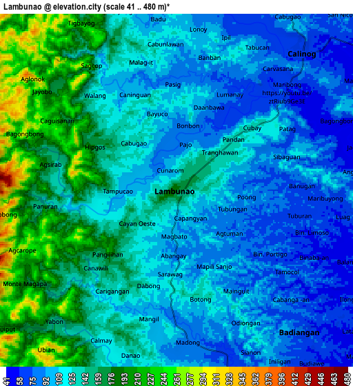
| Scale [m] | 62..272 m | 41..480 m | × |
| Scale [ft] | 203..892 ft | 135..1575 ft | × |
| Average | 114.6 m = 376 ft | 130 m = 427 ft | × |
| Width | 9.59 km = 6 mi | 19.18 km = 11.9 mi | 306.9 km = 190.7 mi |
| Height | 9.59 km = 6 mi | 19.18 km = 11.9 mi | 306.9 km = 190.7 mi |
| ↑Max Latitude | 11.098757° | 11.141877° | 12.43241° |
| Latitude at center | 11.05563° | 11.05563° | 11.05563° |
| ↓Min Latitude | 11.012497° | 10.969358° | 9.67236° |
| ← Min Longitude | 122.431955° | 122.388009° | 121.06965° |
| Longitude center | 122.4759° | 122.4759° | 122.4759° |
| →Max Longitude | 122.519845° | 122.563791° | 123.88215° |
Nearby cities:
Cities around Lambunao sort by population:
• Janiuay elevation 66 m
12.3 km,  164°
164°
• Calinog 51 m
12 km,  55°
55°
• Dueñas 51 m
15.3 km,  85°
85°
• Jayubó 391 m
10.1 km,  266°
266°
• Maribong 56 m
8 km,  51°
51°
• Alibunan 114 m
10.3 km,  349°
349°
• Binabaan 81 m
6.5 km,  128°
128°
• Ponong 37 m
16.7 km,  79°
79°
• Gines-Patay 131 m
13.5 km,  171°
171°
• Quinagaringan 52 m
14.3 km, 58°
• Badlan 72 m
10.7 km,  26°
26°
• Badiangan 90 m
6.2 km,  154°
154°
Multilingual:
 En español:
Lambunao elevación 177 m.
 En France:
Lambunao élévation 177 m.
 Auf Deutsch:
Lambunao höhe über dem Meeresspiegel ist 177 m.

Sources and notes:
- [note 1] Map square and city borders are not equal. Map elevation data is calculated only from area inside that square.
- [src 1] Elevation data from geonames database provided with same terms of usage.
- [src 2] The elevation map of Lambunao is generated using elevation data from NASA's 3 arcsec (90m) resolution SRTM data.
- [src 3] Base (background) map © OpenStreetMap contributors tiles are generated by Geofabrik and OpenTopoMap.
Copyright & License:
This Lambunao Elevation Map is licensed under CC BY-SA. You may reuse any part from this page, if you give a proper credit by linking to this URL:
 More info on terms of use page.