Lutayan elevation
Lutayan (Autonomous Region in Muslim Mindanao, Province of Maguindanao), Philippines elevation is 27 meters and Lutayan elevation in feet is 89 ft above sea level [src 1]. Lutayan is a populated place (feature code) with elevation that is 61 meters (200 ft) smaller than average city elevation in Philippines.
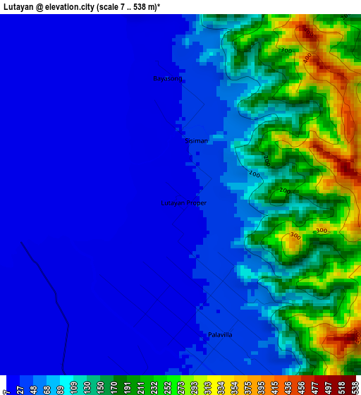
Below is the Elevation map of Lutayan, which displays elevation range with different colors. Scale of the first map is from 7 to 538 m (23 to 1765 ft) with average elevation of 88.1 meters (=289 ft) [note 1]
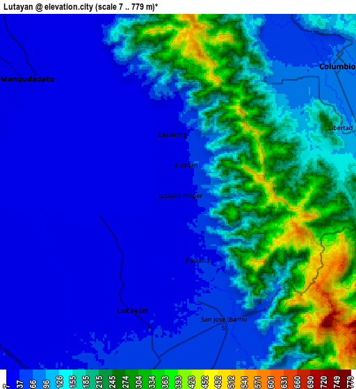
These maps also provides idea of topography and contour of this city, they are displayed at different zoom levels. More info about maps, scale and edge coordinates you can find below images.
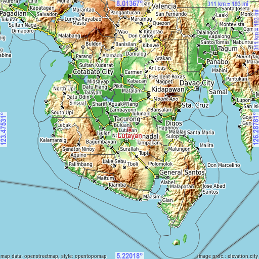
| \ | Map #1 | Map #2 | Topo.Map |
| Scale [m] | 7..538 m | 7..779 m | × |
| Scale [ft] | 23..1765 ft | 23..2556 ft | × |
| Average | 88.1 m = 289 ft | 120.4 m = 395 ft | × |
| Width | 9.71 km = 6 mi | 19.41 km = 12.1 mi | 310.6 km = 193 mi |
| Height | 9.71 km = 6 mi | 19.41 km = 12.1 mi | 310.6 km = 193 mi |
| ↑Max Latitude | 6.66255° | 6.706197° | 8.01367° |
| Latitude at center | 6.6189° | 6.6189° | 6.6189° |
| ↓Min Latitude | 6.575246° | 6.531587° | 5.22018° |
| ← Min Longitude | 124.837615° | 124.793669° | 123.47531° |
| Longitude center | 124.88156° | 124.88156° | 124.88156° |
| →Max Longitude | 124.925505° | 124.969451° | 126.28781° |
Nearby cities:
Cities around Lutayan sort by population:
• Koronadal elevation 52 m
13.4 km,  196°
196°
• Tamnag 48 m
5.1 km,  181°
181°
• Columbio 52 m
10.6 km,  35°
35°
• Blingkong 47 m
3.5 km,  165°
165°
• New Iloilo 27 m
12.9 km,  232°
232°
• Paitan 21 m
4.7 km,  346°
346°
• Maindang 20 m
5 km, 229°
• Bayasong 15 m
3.5 km,  344°
344°
• Mabini 79 m
12.9 km, 166°
• Rotonda 74 m
14.1 km, 177°
• Maibu 15 m
11.1 km,  240°
240°
• Telafas 160 m
10.2 km,  83°
83°
Multilingual:
 En español:
Lutayan elevación 27 m.
 En France:
Lutayan élévation 27 m.


Sources and notes:
- [note 1] Map square and city borders are not equal. Map elevation data is calculated only from area inside that square.
- [src 1] Elevation data from geonames database provided with same terms of usage.
- [src 2] The elevation map of Lutayan is generated using elevation data from NASA's 3 arcsec (90m) resolution SRTM data.
- [src 3] Base (background) map © OpenStreetMap contributors tiles are generated by Geofabrik and OpenTopoMap.
Copyright & License:
This Lutayan Elevation Map is licensed under CC BY-SA. You may reuse any part from this page, if you give a proper credit by linking to this URL:
 More info on terms of use page.