Columbio elevation
Columbio (Soccsksargen, Province of Sultan Kudarat), Philippines elevation is 52 meters and Columbio elevation in feet is 171 ft above sea level [src 1]. Columbio is a seat of a third-order administrative division (feature code) with elevation that is 36 meters (118 ft) smaller than average city elevation in Philippines.
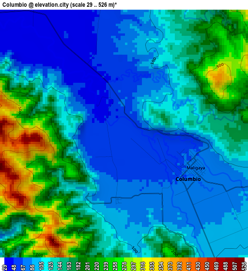
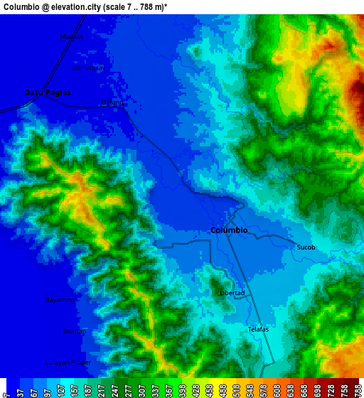
Below is the Elevation map of Columbio, which displays elevation range with different colors. Scale of the first map is from 29 to 526 m (95 to 1726 ft) with average elevation of 140 meters (=459 ft) [note 1]
These maps also provides idea of topography and contour of this city, they are displayed at different zoom levels. More info about maps, scale and edge coordinates you can find below images.
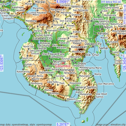
| \ | Map #1 | Map #2 | Topo.Map |
| Scale [m] | 29..526 m | 7..788 m | × |
| Scale [ft] | 95..1726 ft | 23..2585 ft | × |
| Average | 140 m = 459 ft | 178.3 m = 585 ft | × |
| Width | 9.71 km = 6 mi | 19.41 km = 12.1 mi | 310.6 km = 193 mi |
| Height | 9.71 km = 6 mi | 19.41 km = 12.1 mi | 310.6 km = 193 mi |
| ↑Max Latitude | 6.740034° | 6.783673° | 8.09091° |
| Latitude at center | 6.69639° | 6.69639° | 6.69639° |
| ↓Min Latitude | 6.652743° | 6.609091° | 5.29787° |
| ← Min Longitude | 124.893275° | 124.849329° | 123.53097° |
| Longitude center | 124.93722° | 124.93722° | 124.93722° |
| →Max Longitude | 124.981165° | 125.025111° | 126.34347° |
Nearby cities:
Cities around Columbio sort by population:
• Buluan elevation 16 m
15.2 km,  280°
280°
• Lutayan 27 m
10.6 km,  215°
215°
• Tulunan 20 m
16.7 km,  336°
336°
• Tamnag 48 m
15.1 km,  204°
204°
• Blingkong 47 m
13.1 km, 203°
• Bual 33 m
11.4 km,  345°
345°
• Datu Paglas 22 m
12.4 km,  309°
309°
• Paitan 21 m
8.3 km,  240°
240°
• Maindang 20 m
15.5 km, 219°
• Minapan 16 m
15.8 km,  326°
326°
• Bayasong 15 m
8.8 km,  233°
233°
• Telafas 160 m
8.4 km,  151°
151°
Multilingual:
 En español:
Columbio elevación 52 m.
 En France:
Columbio élévation 52 m.


Sources and notes:
- [note 1] Map square and city borders are not equal. Map elevation data is calculated only from area inside that square.
- [src 1] Elevation data from geonames database provided with same terms of usage.
- [src 2] The elevation map of Columbio is generated using elevation data from NASA's 3 arcsec (90m) resolution SRTM data.
- [src 3] Base (background) map © OpenStreetMap contributors tiles are generated by Geofabrik and OpenTopoMap.
Copyright & License:
This Columbio Elevation Map is licensed under CC BY-SA. You may reuse any part from this page, if you give a proper credit by linking to this URL:
 More info on terms of use page.