Maltana elevation
Maltana (Soccsksargen, Province of South Cotabato), Philippines elevation is 153 meters and Maltana elevation in feet is 502 ft above sea level [src 1]. Maltana is a populated place (feature code) with elevation that is 65 meters (213 ft) bigger than average city elevation in Philippines.
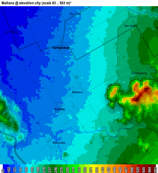
Below is the Elevation map of Maltana, which displays elevation range with different colors. Scale of the first map is from 83 to 583 m (272 to 1913 ft) with average elevation of 176.2 meters (=578 ft) [note 1]
These maps also provides idea of topography and contour of this city, they are displayed at different zoom levels. More info about maps, scale and edge coordinates you can find below images.
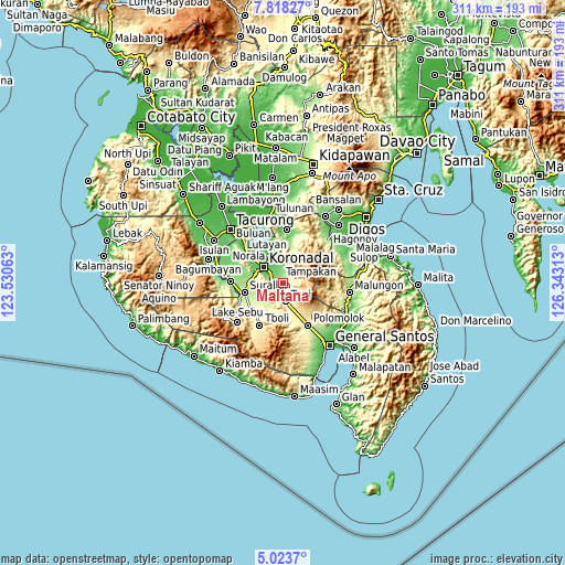
| \ | Map #1 | Topo.Map |
| Scale [m] | 83..583 m | × |
| Scale [ft] | 272..1913 ft | × |
| Average | 176.2 m = 578 ft | × |
| Width | 9.71 km = 6 mi | 310.7 km = 193.1 mi |
| Height | 9.71 km = 6 mi | 310.8 km = 193.1 mi |
| ↑Max Latitude | 6.466568° | 7.81827° |
| Latitude at center | 6.4229° | 6.4229° |
| ↓Min Latitude | 6.379229° | 5.0237° |
| ← Min Longitude | 124.892935° | 123.53063° |
| Longitude center | 124.93688° | 124.93688° |
| →Max Longitude | 124.980825° | 126.34313° |
Nearby cities:
Cities around Maltana sort by population:
• Koronadal elevation 52 m
13.3 km,  311°
311°
• Tupi 317 m
10 km,  169°
169°
• Cebuano 247 m
5.2 km,  138°
138°
• Carpenter Hill 100 m
6.6 km,  291°
291°
• Kipalbig 143 m
1.8 km,  220°
220°
• Linan 273 m
4.5 km,  76°
76°
• Palian 165 m
6.1 km,  208°
208°
• Mabini 79 m
9.7 km,  340°
340°
• Rotonda 74 m
9.5 km,  323°
323°
• Lunen 172 m
7.9 km, 206°
• Lampitak 739 m
12.8 km,  85°
85°
• Liberty 250 m
6.2 km,  54°
54°
Multilingual:
 En español:
Maltana elevación 153 m.
 En France:
Maltana élévation 153 m.


Sources and notes:
- [note 1] Map square and city borders are not equal. Map elevation data is calculated only from area inside that square.
- [src 1] Elevation data from geonames database provided with same terms of usage.
- [src 2] The elevation map of Maltana is generated using elevation data from NASA's 3 arcsec (90m) resolution SRTM data.
- [src 3] Base (background) map © OpenStreetMap contributors tiles are generated by Geofabrik and OpenTopoMap.
Copyright & License:
This Maltana Elevation Map is licensed under CC BY-SA. You may reuse any part from this page, if you give a proper credit by linking to this URL:
 More info on terms of use page.