Tupi elevation
Tupi (Soccsksargen, Province of South Cotabato), Philippines elevation is 317 meters and Tupi elevation in feet is 1040 ft above sea level [src 1]. Tupi is a seat of a third-order administrative division (feature code) with elevation that is 229 meters (751 ft) bigger than average city elevation in Philippines.
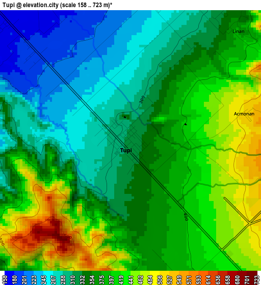
Below is the Elevation map of Tupi, which displays elevation range with different colors. Scale of the first map is from 158 to 723 m (518 to 2372 ft) with average elevation of 361 meters (=1184 ft) [note 1]
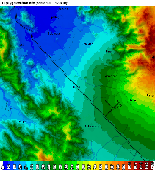
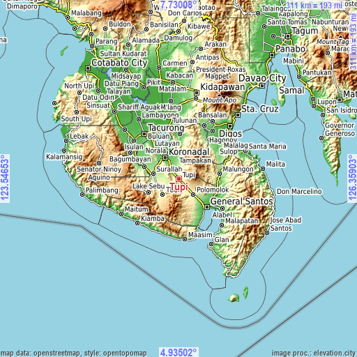
These maps also provides idea of topography and contour of this city, they are displayed at different zoom levels. More info about maps, scale and edge coordinates you can find below images.
| \ | Map #1 | Map #2 | Topo.Map |
| Scale [m] | 158..723 m | 101..1204 m | × |
| Scale [ft] | 518..2372 ft | 331..3950 ft | × |
| Average | 361 m = 1184 ft | 426.3 m = 1399 ft | × |
| Width | 9.71 km = 6 mi | 19.43 km = 12.1 mi | 310.8 km = 193.1 mi |
| Height | 9.71 km = 6 mi | 19.43 km = 12.1 mi | 310.8 km = 193.1 mi |
| ↑Max Latitude | 6.378115° | 6.421787° | 7.73008° |
| Latitude at center | 6.33444° | 6.33444° | 6.33444° |
| ↓Min Latitude | 6.290761° | 6.247079° | 4.93502° |
| ← Min Longitude | 124.908835° | 124.864889° | 123.54653° |
| Longitude center | 124.95278° | 124.95278° | 124.95278° |
| →Max Longitude | 124.996725° | 125.040671° | 126.35903° |
Nearby cities:
Cities around Tupi sort by population:
• Polonoling elevation 377 m
5.8 km,  162°
162°
• Cebuano 247 m
6.2 km,  16°
16°
• Kipalbig 143 m
9 km,  340°
340°
• Kabalen 621 m
6.6 km,  104°
104°
• Koronadal 337 m
10.7 km, 158°
• Palkan 593 m
9.7 km,  115°
115°
• Maltana 153 m
10 km,  349°
349°
• Linan 273 m
11.2 km,  13°
13°
• Pagalungan 422 m
10.2 km,  138°
138°
• Palian 165 m
6.4 km,  313°
313°
• Lunen 172 m
6 km,  297°
297°
• Lampari 254 m
8.4 km,  253°
253°
Multilingual:
 En español:
Tupi elevación 317 m.
 En France:
Tupi élévation 317 m.


Sources and notes:
- [note 1] Map square and city borders are not equal. Map elevation data is calculated only from area inside that square.
- [src 1] Elevation data from geonames database provided with same terms of usage.
- [src 2] The elevation map of Tupi is generated using elevation data from NASA's 3 arcsec (90m) resolution SRTM data.
- [src 3] Base (background) map © OpenStreetMap contributors tiles are generated by Geofabrik and OpenTopoMap.
Copyright & License:
This Tupi Elevation Map is licensed under CC BY-SA. You may reuse any part from this page, if you give a proper credit by linking to this URL:
 More info on terms of use page.