Koronadal elevation
Koronadal (Soccsksargen, Province of South Cotabato), Philippines elevation is 337 meters and Koronadal elevation in feet is 1106 ft above sea level [src 1]. Koronadal is a populated place (feature code) with elevation that is 249 meters (817 ft) bigger than average city elevation in Philippines.
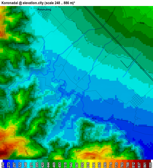
Below is the Elevation map of Koronadal, which displays elevation range with different colors. Scale of the first map is from 248 to 886 m (814 to 2907 ft) with average elevation of 410.3 meters (=1346 ft) [note 1]
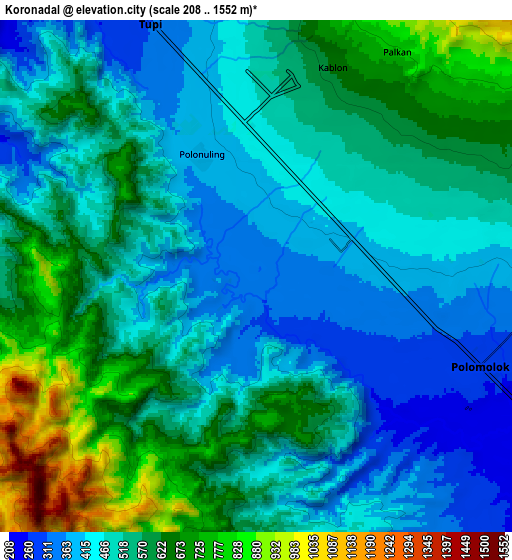
These maps also provides idea of topography and contour of this city, they are displayed at different zoom levels. More info about maps, scale and edge coordinates you can find below images.
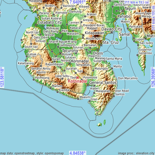
| \ | Map #1 | Map #2 | Topo.Map |
| Scale [m] | 248..886 m | 208..1552 m | × |
| Scale [ft] | 814..2907 ft | 682..5092 ft | × |
| Average | 410.3 m = 1346 ft | 531.1 m = 1742 ft | × |
| Width | 9.71 km = 6 mi | 19.43 km = 12.1 mi | 310.8 km = 193.1 mi |
| Height | 9.71 km = 6 mi | 19.43 km = 12.1 mi | 310.9 km = 193.2 mi |
| ↑Max Latitude | 6.288693° | 6.332372° | 7.64091° |
| Latitude at center | 6.24501° | 6.24501° | 6.24501° |
| ↓Min Latitude | 6.201324° | 6.157634° | 4.84538° |
| ← Min Longitude | 124.943485° | 124.899539° | 123.58118° |
| Longitude center | 124.98743° | 124.98743° | 124.98743° |
| →Max Longitude | 125.031375° | 125.075321° | 126.39368° |
Nearby cities:
Cities around Koronadal sort by population:
• Polomolok elevation 300 m
8.9 km,  107°
107°
• Tupi 317 m
10.7 km,  338°
338°
• Polonoling 377 m
4.9 km, 335°
• Sulit 343 m
3.8 km, 105°
• Kabalen 621 m
8.7 km,  17°
17°
• Glamang 228 m
14.1 km,  130°
130°
• Upper Klinan 288 m
14.9 km,  97°
97°
• Palkan 593 m
7.5 km,  40°
40°
• Pagalungan 422 m
3.7 km,  51°
51°
• Polo 452 m
14 km,  80°
80°
• Lunen 172 m
15.6 km,  324°
324°
• Lampari 254 m
14 km,  302°
302°
Multilingual:
 En español:
Koronadal elevación 337 m.
 En France:
Koronadal élévation 337 m.
 Auf Deutsch:
Koronadal höhe über dem Meeresspiegel ist 337 m.

Sources and notes:
- [note 1] Map square and city borders are not equal. Map elevation data is calculated only from area inside that square.
- [src 1] Elevation data from geonames database provided with same terms of usage.
- [src 2] The elevation map of Koronadal is generated using elevation data from NASA's 3 arcsec (90m) resolution SRTM data.
- [src 3] Base (background) map © OpenStreetMap contributors tiles are generated by Geofabrik and OpenTopoMap.
Copyright & License:
This Koronadal Elevation Map is licensed under CC BY-SA. You may reuse any part from this page, if you give a proper credit by linking to this URL:
 More info on terms of use page.