Maygatasan elevation
Maygatasan (Caraga, Province of Agusan del Sur), Philippines elevation is 27 meters and Maygatasan elevation in feet is 89 ft above sea level [src 1]. Maygatasan is a populated place (feature code) with elevation that is 61 meters (200 ft) smaller than average city elevation in Philippines.
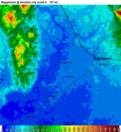
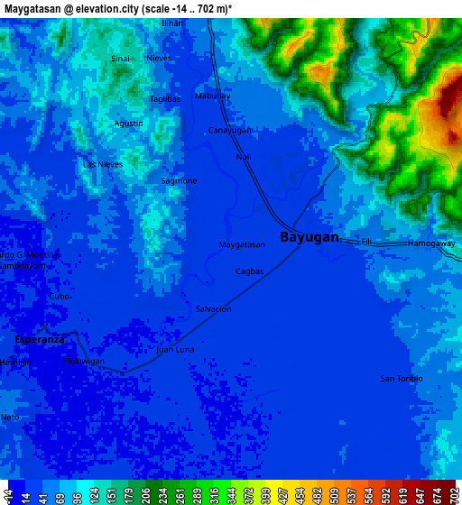
Below is the Elevation map of Maygatasan, which displays elevation range with different colors. Scale of the first map is from 8 to 187 m (26 to 614 ft) with average elevation of 34.3 meters (=113 ft) [note 1]
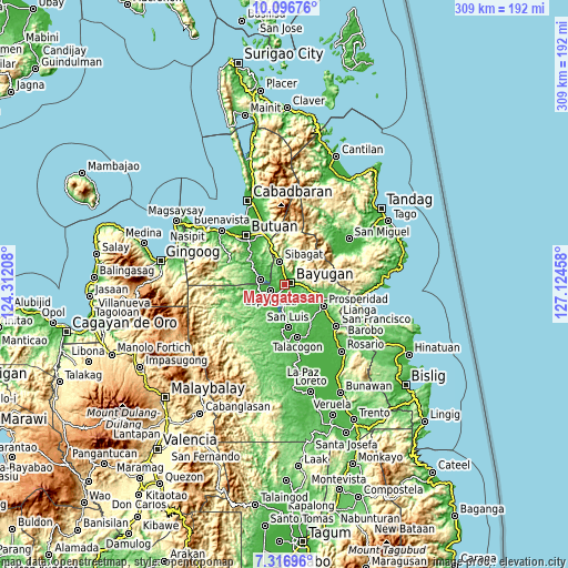
These maps also provides idea of topography and contour of this city, they are displayed at different zoom levels. More info about maps, scale and edge coordinates you can find below images.
| \ | Map #1 | Map #2 | Topo.Map |
| Scale [m] | 8..187 m | -14..702 m | × |
| Scale [ft] | 26..614 ft | -46..2303 ft | × |
| Average | 34.3 m = 113 ft | 73.9 m = 242 ft | × |
| Width | 9.66 km = 6 mi | 19.32 km = 12 mi | 309.1 km = 192.1 mi |
| Height | 9.66 km = 6 mi | 19.32 km = 12 mi | 309.1 km = 192.1 mi |
| ↑Max Latitude | 8.752876° | 8.796307° | 10.09676° |
| Latitude at center | 8.70944° | 8.70944° | 8.70944° |
| ↓Min Latitude | 8.665999° | 8.622553° | 7.31696° |
| ← Min Longitude | 125.674385° | 125.630439° | 124.31208° |
| Longitude center | 125.71833° | 125.71833° | 125.71833° |
| →Max Longitude | 125.762275° | 125.806221° | 127.12458° |
Nearby cities:
Cities around Maygatasan sort by population:
• Bayugan elevation 65 m
7.5 km,  46°
46°
• Bah-Bah 43 m
24.4 km,  117°
117°
• Tungao 24 m
15.8 km,  301°
301°
• Taligaman 199 m
22.7 km,  342°
342°
• San Luis 16 m
25.9 km,  173°
173°
• Esperanza 14 m
8.6 km,  245°
245°
• Salvacion 13 m
4.1 km,  210°
210°
• Sibagat 46 m
12.8 km,  349°
349°
• Guadalupe 25 m
14.1 km,  184°
184°
• Kauswagan 64 m
21.7 km, 170°
• Aurora 41 m
18.4 km,  134°
134°
• Prosperidad 39 m
24.3 km, 126°
Multilingual:
 En español:
Maygatasan elevación 27 m.
 En France:
Maygatasan élévation 27 m.
 Auf Deutsch:
Maygatasan höhe über dem Meeresspiegel ist 27 m.

Sources and notes:
- [note 1] Map square and city borders are not equal. Map elevation data is calculated only from area inside that square.
- [src 1] Elevation data from geonames database provided with same terms of usage.
- [src 2] The elevation map of Maygatasan is generated using elevation data from NASA's 3 arcsec (90m) resolution SRTM data.
- [src 3] Base (background) map © OpenStreetMap contributors tiles are generated by Geofabrik and OpenTopoMap.
Copyright & License:
This Maygatasan Elevation Map is licensed under CC BY-SA. You may reuse any part from this page, if you give a proper credit by linking to this URL:
 More info on terms of use page.