Tungao elevation
Tungao (Caraga, Province of Agusan del Norte), Philippines elevation is 24 meters and Tungao elevation in feet is 79 ft above sea level [src 1]. Tungao is a populated place (feature code) with elevation that is 64 meters (210 ft) smaller than average city elevation in Philippines.
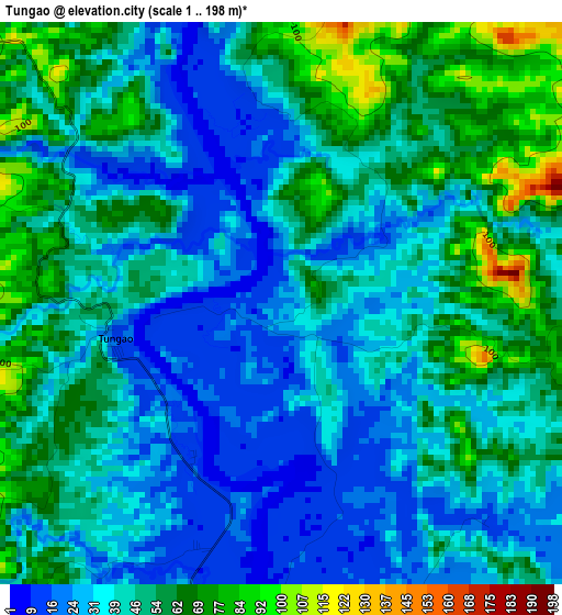
Below is the Elevation map of Tungao, which displays elevation range with different colors. Scale of the first map is from 1 to 198 m (3 to 650 ft) with average elevation of 44.6 meters (=146 ft) [note 1]
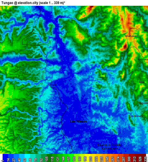
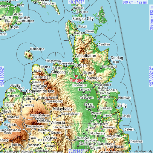
These maps also provides idea of topography and contour of this city, they are displayed at different zoom levels. More info about maps, scale and edge coordinates you can find below images.
| \ | Map #1 | Map #2 | Topo.Map |
| Scale [m] | 1..198 m | 1..339 m | × |
| Scale [ft] | 3..650 ft | 3..1112 ft | × |
| Average | 44.6 m = 146 ft | 80.7 m = 265 ft | × |
| Width | 9.66 km = 6 mi | 19.32 km = 12 mi | 309 km = 192 mi |
| Height | 9.66 km = 6 mi | 19.32 km = 12 mi | 309.1 km = 192.1 mi |
| ↑Max Latitude | 8.827107° | 8.87053° | 10.1707° |
| Latitude at center | 8.78368° | 8.78368° | 8.78368° |
| ↓Min Latitude | 8.740248° | 8.69681° | 7.39145° |
| ← Min Longitude | 125.551925° | 125.507979° | 124.18962° |
| Longitude center | 125.59587° | 125.59587° | 125.59587° |
| →Max Longitude | 125.639815° | 125.683761° | 127.00212° |
Nearby cities:
Cities around Tungao sort by population:
• Butuan elevation 9 m
19.3 km,  342°
342°
• Libertad 8 m
20.6 km,  329°
329°
• Bayugan 65 m
19.1 km,  99°
99°
• Taligaman 199 m
15 km,  26°
26°
• Esperanza 14 m
13.1 km,  154°
154°
• Salvacion 13 m
16.4 km,  136°
136°
• Sibagat 46 m
12 km,  68°
68°
• Guinabsan 34 m
23.5 km,  302°
302°
• Maygatasan 27 m
15.8 km,  121°
121°
• Bancasi 3 m
24.8 km, 325°
• Anticala 70 m
25.1 km,  12°
12°
• Basag 67 m
16 km, 10°
Multilingual:
 En español:
Tungao elevación 24 m.
 En France:
Tungao élévation 24 m.


Sources and notes:
- [note 1] Map square and city borders are not equal. Map elevation data is calculated only from area inside that square.
- [src 1] Elevation data from geonames database provided with same terms of usage.
- [src 2] The elevation map of Tungao is generated using elevation data from NASA's 3 arcsec (90m) resolution SRTM data.
- [src 3] Base (background) map © OpenStreetMap contributors tiles are generated by Geofabrik and OpenTopoMap.
Copyright & License:
This Tungao Elevation Map is licensed under CC BY-SA. You may reuse any part from this page, if you give a proper credit by linking to this URL:
 More info on terms of use page.