Payapa elevation
Payapa (Calabarzon, Province of Batangas), Philippines elevation is 358 meters and Payapa elevation in feet is 1175 ft above sea level [src 1]. Payapa is a populated place (feature code) with elevation that is 270 meters (886 ft) bigger than average city elevation in Philippines.
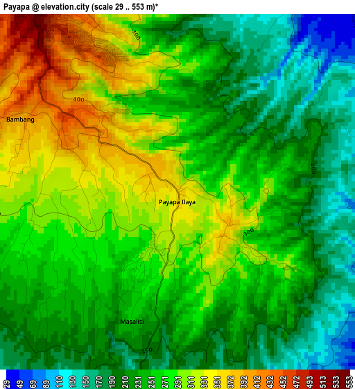
Below is the Elevation map of Payapa, which displays elevation range with different colors. Scale of the first map is from 29 to 553 m (95 to 1814 ft) with average elevation of 258 meters (=846 ft) [note 1]
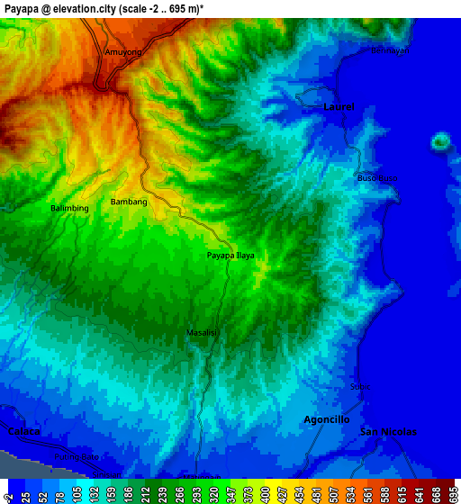
These maps also provides idea of topography and contour of this city, they are displayed at different zoom levels. More info about maps, scale and edge coordinates you can find below images.
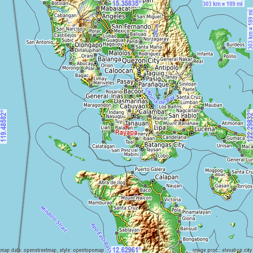
| \ | Map #1 | Map #2 | Topo.Map |
| Scale [m] | 29..553 m | -2..695 m | × |
| Scale [ft] | 95..1814 ft | -7..2280 ft | × |
| Average | 258 m = 846 ft | 187.8 m = 616 ft | × |
| Width | 9.48 km = 5.9 mi | 18.96 km = 11.8 mi | 303.4 km = 188.5 mi |
| Height | 9.48 km = 5.9 mi | 18.96 km = 11.8 mi | 303.4 km = 188.5 mi |
| ↑Max Latitude | 14.040666° | 14.083295° | 15.35835° |
| Latitude at center | 13.99803° | 13.99803° | 13.99803° |
| ↓Min Latitude | 13.955386° | 13.912734° | 12.62961° |
| ← Min Longitude | 120.848125° | 120.804179° | 119.48582° |
| Longitude center | 120.89207° | 120.89207° | 120.89207° |
| →Max Longitude | 120.936015° | 120.979961° | 122.29832° |
Nearby cities:
Cities around Payapa sort by population:
• Tagaytay elevation 663 m
11.7 km,  22°
22°
• Calaca 24 m
11.2 km,  229°
229°
• Laurel 81 m
7 km, 24°
• Subic 21 m
7.6 km,  136°
136°
• Luksuhin 569 m
11 km,  353°
353°
• Matingain 20 m
9.6 km,  187°
187°
• Bugaan 30 m
6.6 km,  45°
45°
• Sinisian 17 m
10.5 km,  209°
209°
• Calantas 79 m
13 km,  257°
257°
• Dayapan 88 m
7.2 km,  158°
158°
• San Nicolas 24 m
10 km, 140°
• Agoncillo 61 m
8.2 km,  147°
147°
Multilingual:
 En español:
Payapa elevación 358 m.
 En France:
Payapa élévation 358 m.


Sources and notes:
- [note 1] Map square and city borders are not equal. Map elevation data is calculated only from area inside that square.
- [src 1] Elevation data from geonames database provided with same terms of usage.
- [src 2] The elevation map of Payapa is generated using elevation data from NASA's 3 arcsec (90m) resolution SRTM data.
- [src 3] Base (background) map © OpenStreetMap contributors tiles are generated by Geofabrik and OpenTopoMap.
Copyright & License:
This Payapa Elevation Map is licensed under CC BY-SA. You may reuse any part from this page, if you give a proper credit by linking to this URL:
 More info on terms of use page.