Matingain elevation
Matingain (Calabarzon, Province of Batangas), Philippines elevation is 20 meters and Matingain elevation in feet is 66 ft above sea level [src 1]. Matingain is a populated place (feature code) with elevation that is 68 meters (223 ft) smaller than average city elevation in Philippines.
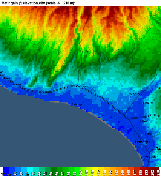
Below is the Elevation map of Matingain, which displays elevation range with different colors. Scale of the first map is from -6 to 210 m (-20 to 689 ft) with average elevation of 72.7 meters (=239 ft) [note 1]
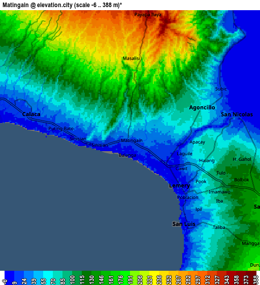
These maps also provides idea of topography and contour of this city, they are displayed at different zoom levels. More info about maps, scale and edge coordinates you can find below images.
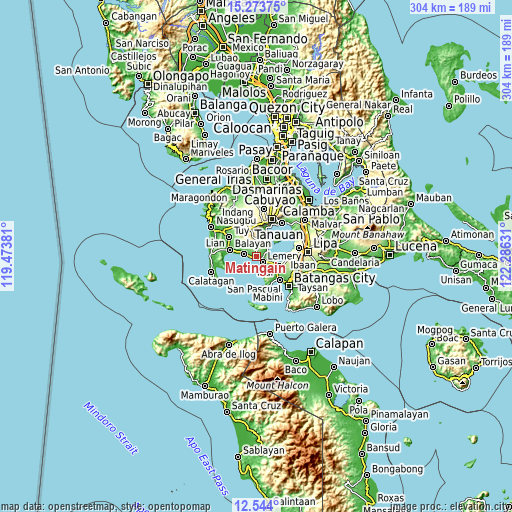
| \ | Map #1 | Map #2 | Topo.Map |
| Scale [m] | -6..210 m | -6..388 m | × |
| Scale [ft] | -20..689 ft | -20..1273 ft | × |
| Average | 72.7 m = 239 ft | 109.9 m = 361 ft | × |
| Width | 9.49 km = 5.9 mi | 18.97 km = 11.8 mi | 303.5 km = 188.6 mi |
| Height | 9.49 km = 5.9 mi | 18.97 km = 11.8 mi | 303.5 km = 188.6 mi |
| ↑Max Latitude | 13.955552° | 13.998196° | 15.27375° |
| Latitude at center | 13.9129° | 13.9129° | 13.9129° |
| ↓Min Latitude | 13.87024° | 13.827572° | 12.544° |
| ← Min Longitude | 120.836115° | 120.792169° | 119.47381° |
| Longitude center | 120.88006° | 120.88006° | 120.88006° |
| →Max Longitude | 120.924005° | 120.967951° | 122.28631° |
Nearby cities:
Cities around Matingain sort by population:
• Taal elevation 42 m
5.9 km,  128°
128°
• Calaca 24 m
7.5 km,  286°
286°
• Subic 21 m
7.6 km,  58°
58°
• Payapa 358 m
9.6 km,  7°
7°
• Sinisian 17 m
3.9 km,  274°
274°
• Santa Teresita 176 m
12.1 km,  115°
115°
• Dayapan 88 m
4.7 km, 55°
• San Nicolas 24 m
7.8 km,  77°
77°
• San Jose 98 m
10.1 km, 132°
• San Luis 8 m
7.6 km,  148°
148°
• Agoncillo 61 m
6.2 km,  66°
66°
• Lemery 9 m
5.1 km, 134°
Multilingual:
 En español:
Matingain elevación 20 m.
 En France:
Matingain élévation 20 m.
 Auf Deutsch:
Matingain höhe über dem Meeresspiegel ist 20 m.

Sources and notes:
- [note 1] Map square and city borders are not equal. Map elevation data is calculated only from area inside that square.
- [src 1] Elevation data from geonames database provided with same terms of usage.
- [src 2] The elevation map of Matingain is generated using elevation data from NASA's 3 arcsec (90m) resolution SRTM data.
- [src 3] Base (background) map © OpenStreetMap contributors tiles are generated by Geofabrik and OpenTopoMap.
Copyright & License:
This Matingain Elevation Map is licensed under CC BY-SA. You may reuse any part from this page, if you give a proper credit by linking to this URL:
 More info on terms of use page.