Plaridel elevation
Plaridel (Central Luzon, Province of Nueva Ecija), Philippines elevation is 72 meters and Plaridel elevation in feet is 236 ft above sea level [src 1]. Plaridel is a populated place (feature code) with elevation that is 16 meters (52 ft) smaller than average city elevation in Philippines.
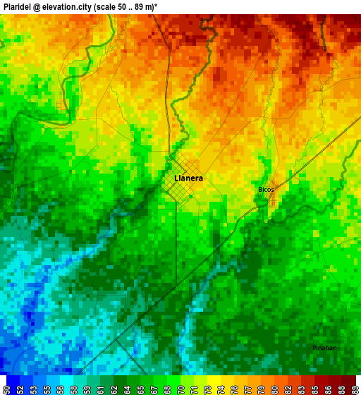
Below is the Elevation map of Plaridel, which displays elevation range with different colors. Scale of the first map is from 50 to 89 m (164 to 292 ft) with average elevation of 68.6 meters (=225 ft) [note 1]
These maps also provides idea of topography and contour of this city, they are displayed at different zoom levels. More info about maps, scale and edge coordinates you can find below images.

| \ | Map #1 | Topo.Map |
| Scale [m] | 50..89 m | × |
| Scale [ft] | 164..292 ft | × |
| Average | 68.6 m = 225 ft | × |
| Width | 9.41 km = 5.8 mi | 301.1 km = 187.1 mi |
| Height | 9.41 km = 5.8 mi | 301.1 km = 187.1 mi |
| ↑Max Latitude | 15.70084° | 17.00799° |
| Latitude at center | 15.65853° | 15.65853° |
| ↓Min Latitude | 15.616211° | 14.3001° |
| ← Min Longitude | 120.976145° | 119.61384° |
| Longitude center | 121.02009° | 121.02009° |
| →Max Longitude | 121.064035° | 122.42634° |
Nearby cities:
Cities around Plaridel sort by population:
• General Mamerto Natividad elevation 60 m
7.1 km,  151°
151°
• Mabini 48 m
7.6 km,  211°
211°
• Llanera 70 m
0.6 km,  339°
339°
• Estrella 101 m
10.3 km,  7°
7°
• Bicos 76 m
2.3 km,  85°
85°
• Agbannawag 84 m
7.1 km,  71°
71°
• Del Pilar 80 m
8.2 km,  59°
59°
• Tabacao 59 m
8.6 km,  263°
263°
• Tondod 86 m
8.7 km,  319°
319°
• Piñahan 68 m
5.7 km,  128°
128°
• Paco Roman 77 m
7.2 km, 88°
• San Ricardo 52 m
8.6 km,  216°
216°
Multilingual:
 En español:
Plaridel elevación 72 m.
 En France:
Plaridel élévation 72 m.


Sources and notes:
- [note 1] Map square and city borders are not equal. Map elevation data is calculated only from area inside that square.
- [src 1] Elevation data from geonames database provided with same terms of usage.
- [src 2] The elevation map of Plaridel is generated using elevation data from NASA's 3 arcsec (90m) resolution SRTM data.
- [src 3] Base (background) map © OpenStreetMap contributors tiles are generated by Geofabrik and OpenTopoMap.
Copyright & License:
This Plaridel Elevation Map is licensed under CC BY-SA. You may reuse any part from this page, if you give a proper credit by linking to this URL:
 More info on terms of use page.