Tondod elevation
Tondod (Central Luzon, Province of Nueva Ecija), Philippines elevation is 86 meters and Tondod elevation in feet is 282 ft above sea level [src 1]. Tondod is a populated place (feature code) with elevation that is 2 meters (7 ft) smaller than average city elevation in Philippines.
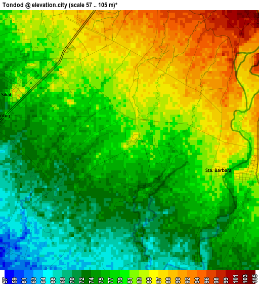
Below is the Elevation map of Tondod, which displays elevation range with different colors. Scale of the first map is from 57 to 105 m (187 to 344 ft) with average elevation of 79.1 meters (=260 ft) [note 1]
These maps also provides idea of topography and contour of this city, they are displayed at different zoom levels. More info about maps, scale and edge coordinates you can find below images.
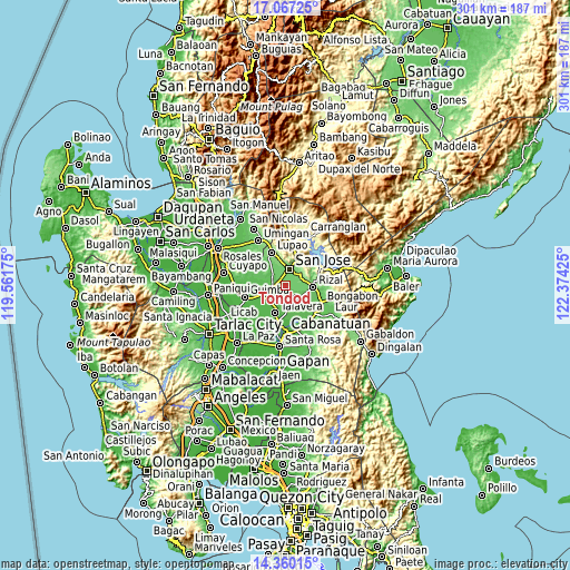
| \ | Map #1 | Topo.Map |
| Scale [m] | 57..105 m | × |
| Scale [ft] | 187..344 ft | × |
| Average | 79.1 m = 260 ft | × |
| Width | 9.41 km = 5.8 mi | 301 km = 187 mi |
| Height | 9.41 km = 5.8 mi | 301 km = 187 mi |
| ↑Max Latitude | 15.760498° | 17.06725° |
| Latitude at center | 15.7182° | 15.7182° |
| ↓Min Latitude | 15.675894° | 14.36015° |
| ← Min Longitude | 120.924055° | 119.56175° |
| Longitude center | 120.968° | 120.968° |
| →Max Longitude | 121.011945° | 122.37425° |
Nearby cities:
Cities around Tondod sort by population:
• Muñoz elevation 70 m
7 km,  268°
268°
• Santo Tomas 88 m
3.6 km,  350°
350°
• Llanera 70 m
8.1 km,  138°
138°
• Estrella 101 m
7.8 km,  63°
63°
• Maligaya 60 m
9.8 km,  240°
240°
• Bicos 76 m
10.2 km,  129°
129°
• Tabacao 59 m
8.2 km,  201°
201°
• Porais 117 m
9 km, 62°
• Plaridel 72 m
8.7 km, 139°
• Palusapis 53 m
11.9 km,  250°
250°
• Sibul 114 m
9.7 km,  20°
20°
• Magtangol 78 m
7.1 km,  308°
308°
Multilingual:
 En español:
Tondod elevación 86 m.
 En France:
Tondod élévation 86 m.


Sources and notes:
- [note 1] Map square and city borders are not equal. Map elevation data is calculated only from area inside that square.
- [src 1] Elevation data from geonames database provided with same terms of usage.
- [src 2] The elevation map of Tondod is generated using elevation data from NASA's 3 arcsec (90m) resolution SRTM data.
- [src 3] Base (background) map © OpenStreetMap contributors tiles are generated by Geofabrik and OpenTopoMap.
Copyright & License:
This Tondod Elevation Map is licensed under CC BY-SA. You may reuse any part from this page, if you give a proper credit by linking to this URL:
 More info on terms of use page.