Surallah elevation
Surallah (Soccsksargen, Province of South Cotabato), Philippines elevation is 195 meters and Surallah elevation in feet is 640 ft above sea level [src 1]. Surallah is a seat of a third-order administrative division (feature code) with elevation that is 107 meters (351 ft) bigger than average city elevation in Philippines.
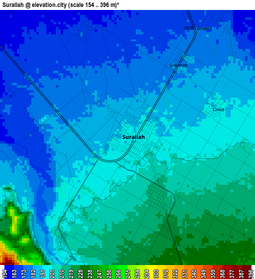
Below is the Elevation map of Surallah, which displays elevation range with different colors. Scale of the first map is from 154 to 396 m (505 to 1299 ft) with average elevation of 192 meters (=630 ft) [note 1]
These maps also provides idea of topography and contour of this city, they are displayed at different zoom levels. More info about maps, scale and edge coordinates you can find below images.

| \ | Map #1 | Map #2 | Topo.Map |
| Scale [m] | 154..396 m | 121..959 m | × |
| Scale [ft] | 505..1299 ft | 397..3146 ft | × |
| Average | 192 m = 630 ft | 249 m = 817 ft | × |
| Width | 9.71 km = 6 mi | 19.42 km = 12.1 mi | 310.8 km = 193.1 mi |
| Height | 9.71 km = 6 mi | 19.42 km = 12.1 mi | 310.8 km = 193.1 mi |
| ↑Max Latitude | 6.418942° | 6.46261° | 7.77078° |
| Latitude at center | 6.37527° | 6.37527° | 6.37527° |
| ↓Min Latitude | 6.331595° | 6.287915° | 4.97595° |
| ← Min Longitude | 124.701265° | 124.657319° | 123.33896° |
| Longitude center | 124.74521° | 124.74521° | 124.74521° |
| →Max Longitude | 124.789155° | 124.833101° | 126.15146° |
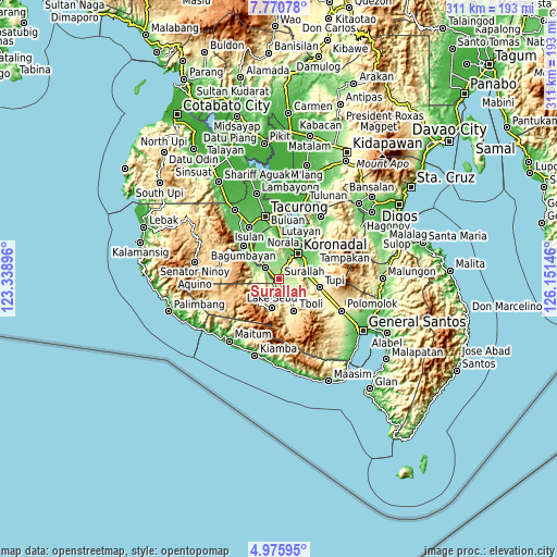
Nearby cities:
Cities around Surallah sort by population:
• Bañga elevation 165 m
6.5 km,  34°
34°
• Santo Niño 148 m
8.5 km,  321°
321°
• Dahay 174 m
3.8 km,  296°
296°
• Lamba 224 m
8.7 km,  108°
108°
• Lopez Jaena 124 m
12.3 km,  335°
335°
• Colongulo 200 m
4.8 km,  212°
212°
• Manuel Roxas 138 m
11.5 km,  310°
310°
• Lambontong 271 m
10.4 km,  135°
135°
• Paraiso 88 m
13.3 km, 32°
• Guinsang-an 128 m
12 km,  326°
326°
• San Vicente 155 m
9.5 km,  23°
23°
• Teresita 154 m
6 km, 316°
Multilingual:
 En español:
Surala elevación 195 m.
 En France:
Surallah élévation 195 m.
 Auf Deutsch:
Surallah höhe über dem Meeresspiegel ist 195 m.

Sources and notes:
- [note 1] Map square and city borders are not equal. Map elevation data is calculated only from area inside that square.
- [src 1] Elevation data from geonames database provided with same terms of usage.
- [src 2] The elevation map of Surallah is generated using elevation data from NASA's 3 arcsec (90m) resolution SRTM data.
- [src 3] Base (background) map © OpenStreetMap contributors tiles are generated by Geofabrik and OpenTopoMap.
Copyright & License:
This Surallah Elevation Map is licensed under CC BY-SA. You may reuse any part from this page, if you give a proper credit by linking to this URL:
 More info on terms of use page.