Lamba elevation
Lamba (Soccsksargen, Province of South Cotabato), Philippines elevation is 224 meters and Lamba elevation in feet is 735 ft above sea level [src 1]. Lamba is a populated place (feature code) with elevation that is 136 meters (446 ft) bigger than average city elevation in Philippines.
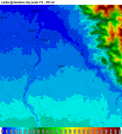
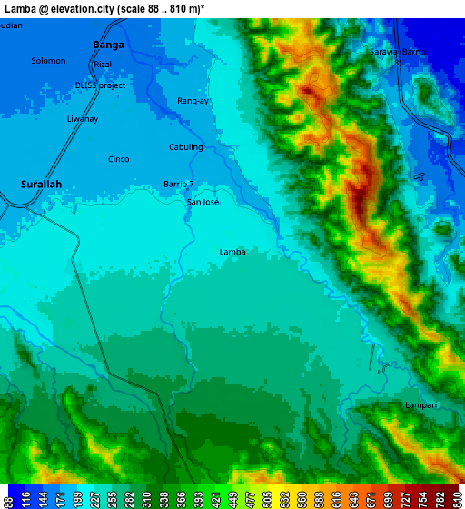
Below is the Elevation map of Lamba, which displays elevation range with different colors. Scale of the first map is from 172 to 653 m (564 to 2142 ft) with average elevation of 248.8 meters (=816 ft) [note 1]
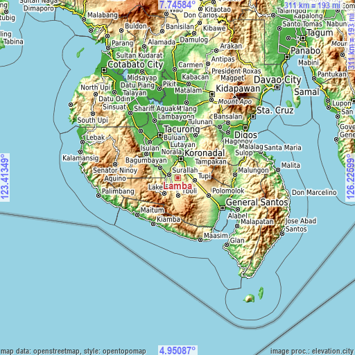
These maps also provides idea of topography and contour of this city, they are displayed at different zoom levels. More info about maps, scale and edge coordinates you can find below images.
| \ | Map #1 | Map #2 | Topo.Map |
| Scale [m] | 172..653 m | 88..810 m | × |
| Scale [ft] | 564..2142 ft | 289..2657 ft | × |
| Average | 248.8 m = 816 ft | 275.2 m = 903 ft | × |
| Width | 9.71 km = 6 mi | 19.43 km = 12.1 mi | 310.8 km = 193.1 mi |
| Height | 9.71 km = 6 mi | 19.43 km = 12.1 mi | 310.8 km = 193.1 mi |
| ↑Max Latitude | 6.393924° | 6.437594° | 7.74584° |
| Latitude at center | 6.35025° | 6.35025° | 6.35025° |
| ↓Min Latitude | 6.306572° | 6.262891° | 4.95087° |
| ← Min Longitude | 124.775795° | 124.731849° | 123.41349° |
| Longitude center | 124.81974° | 124.81974° | 124.81974° |
| →Max Longitude | 124.863685° | 124.907631° | 126.22599° |
Nearby cities:
Cities around Lamba sort by population:
• Bañga elevation 165 m
9.4 km,  330°
330°
• Surallah 195 m
8.7 km,  288°
288°
• Dahay 174 m
12.5 km, 291°
• Carpenter Hill 100 m
12.5 km,  33°
33°
• Colongulo 200 m
10.9 km,  263°
263°
• Lambontong 271 m
4.8 km,  192°
192°
• Lamian 257 m
5.4 km,  147°
147°
• San Vicente 155 m
12.3 km,  339°
339°
• Palian 165 m
10.4 km,  75°
75°
• Sinolon 422 m
11.8 km,  182°
182°
• Lunen 172 m
9.4 km, 84°
• Lampari 254 m
7.9 km,  122°
122°
Multilingual:
 En español:
Lamba elevación 224 m.
 En France:
Lamba élévation 224 m.


Sources and notes:
- [note 1] Map square and city borders are not equal. Map elevation data is calculated only from area inside that square.
- [src 1] Elevation data from geonames database provided with same terms of usage.
- [src 2] The elevation map of Lamba is generated using elevation data from NASA's 3 arcsec (90m) resolution SRTM data.
- [src 3] Base (background) map © OpenStreetMap contributors tiles are generated by Geofabrik and OpenTopoMap.
Copyright & License:
This Lamba Elevation Map is licensed under CC BY-SA. You may reuse any part from this page, if you give a proper credit by linking to this URL:
 More info on terms of use page.