Ternate elevation
Ternate (Calabarzon, Province of Cavite), Philippines elevation is 9 meters and Ternate elevation in feet is 30 ft above sea level [src 1]. Ternate is a seat of a third-order administrative division (feature code) with elevation that is 79 meters (259 ft) smaller than average city elevation in Philippines.
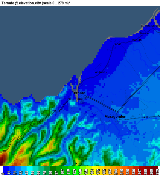
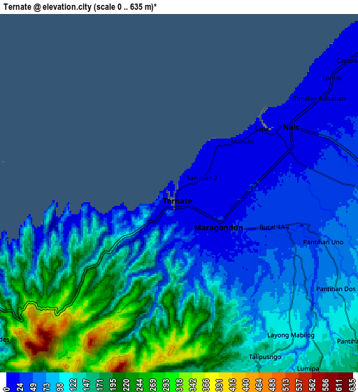
Below is the Elevation map of Ternate, which displays elevation range with different colors. Scale of the first map is from 0 to 279 m (0 to 915 ft) with average elevation of 42.7 meters (=140 ft) [note 1]
These maps also provides idea of topography and contour of this city, they are displayed at different zoom levels. More info about maps, scale and edge coordinates you can find below images.
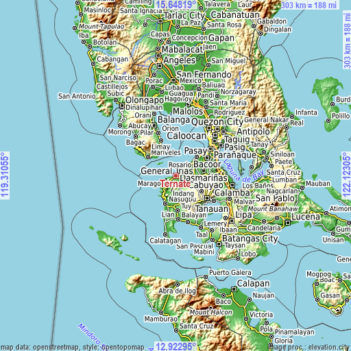
| \ | Map #1 | Map #2 | Topo.Map |
| Scale [m] | 0..279 m | 0..635 m | × |
| Scale [ft] | 0..915 ft | 0..2083 ft | × |
| Average | 42.7 m = 140 ft | 115.4 m = 379 ft | × |
| Width | 9.47 km = 5.9 mi | 18.94 km = 11.8 mi | 303 km = 188.3 mi |
| Height | 9.47 km = 5.9 mi | 18.94 km = 11.8 mi | 303 km = 188.3 mi |
| ↑Max Latitude | 14.332282° | 14.374855° | 15.64819° |
| Latitude at center | 14.2897° | 14.2897° | 14.2897° |
| ↓Min Latitude | 14.24711° | 14.204513° | 12.92295° |
| ← Min Longitude | 120.672855° | 120.628909° | 119.31055° |
| Longitude center | 120.7168° | 120.7168° | 120.7168° |
| →Max Longitude | 120.760745° | 120.804691° | 122.12305° |
Nearby cities:
Cities around Ternate sort by population:
• Naic elevation 15 m
6.2 km,  59°
59°
• Maragondon 21 m
2.9 km,  128°
128°
• General Emilio Aguinaldo 213 m
14.5 km,  144°
144°
• Halayhay 7 m
14 km,  48°
48°
• Palangue 61 m
10.2 km,  93°
93°
• Paradahan 66 m
15.9 km,  77°
77°
• Pantijan No 2 104 m
11 km,  124°
124°
• Sabang 38 m
9.5 km, 79°
• Magallanes 169 m
12.1 km,  158°
158°
• Tulay 40 m
6.1 km,  111°
111°
• Malainen Luma 50 m
8 km, 105°
• Batas 201 m
14.7 km, 132°
Multilingual:
 En español:
Ternate elevación 9 m.
 En France:
Ternate élévation 9 m.


Sources and notes:
- [note 1] Map square and city borders are not equal. Map elevation data is calculated only from area inside that square.
- [src 1] Elevation data from geonames database provided with same terms of usage.
- [src 2] The elevation map of Ternate is generated using elevation data from NASA's 3 arcsec (90m) resolution SRTM data.
- [src 3] Base (background) map © OpenStreetMap contributors tiles are generated by Geofabrik and OpenTopoMap.
Copyright & License:
This Ternate Elevation Map is licensed under CC BY-SA. You may reuse any part from this page, if you give a proper credit by linking to this URL:
 More info on terms of use page.