Vanimo elevation
Vanimo (Sandaun), Papua New Guinea elevation is 5 meters and Vanimo elevation in feet is 16 ft above sea level [src 1]. Vanimo is a seat of a first-order administrative division (feature code) with elevation that is 557 meters (1827 ft) smaller than average city elevation in Papua New Guinea.
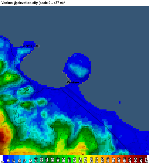
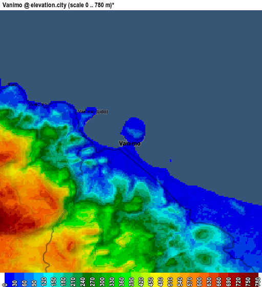
Below is the Elevation map of Vanimo, which displays elevation range with different colors. Scale of the first map is from 0 to 477 m (0 to 1565 ft) with average elevation of 91.8 meters (=301 ft) [note 1]
These maps also provides idea of topography and contour of this city, they are displayed at different zoom levels. More info about maps, scale and edge coordinates you can find below images.
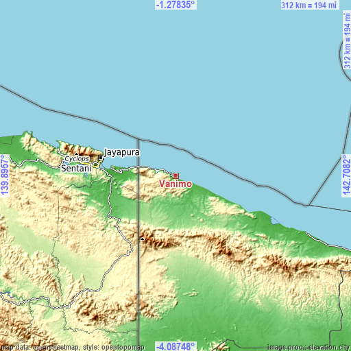
| \ | Map #1 | Map #2 | Topo.Map |
| Scale [m] | 0..477 m | 0..780 m | × |
| Scale [ft] | 0..1565 ft | 0..2559 ft | × |
| Average | 91.8 m = 301 ft | 263.4 m = 864 ft | × |
| Width | 9.76 km = 6.1 mi | 19.52 km = 12.1 mi | 312.3 km = 194.1 mi |
| Height | 9.76 km = 6.1 mi | 19.52 km = 12.1 mi | 312.4 km = 194.1 mi |
| ↑Max Latitude | -2.639822° | -2.595923° | -1.27835° |
| Latitude at center | -2.68372° | -2.68372° | -2.68372° |
| ↓Min Latitude | -2.727616° | -2.771511° | -4.08748° |
| ← Min Longitude | 141.258005° | 141.214059° | 139.8957° |
| Longitude center | 141.30195° | 141.30195° | 141.30195° |
| →Max Longitude | 141.345895° | 141.389841° | 142.7082° |
Nearby cities:
Cities around Vanimo sort by population:
• Wewak elevation 44 m
276.1 km,  110°
110°
• Kiunga 40 m
382.3 km,  180°
180°
• Tari 1676 m
396 km,  152°
152°
• Aitape 1 m
126.7 km, 113°
• Wabag 2069 m
411.6 km,  139°
139°
• Ambunti 29 m
239.6 km, 135°
• Angoram 0 m
343 km,  116°
116°
• Porgera 2248 m
370.7 km, 146°
Multilingual:
 En español:
Vanimo elevación 5 m.
 En France:
Vanimo élévation 5 m.


Sources and notes:
- [note 1] Map square and city borders are not equal. Map elevation data is calculated only from area inside that square.
- [src 1] Elevation data from geonames database provided with same terms of usage.
- [src 2] The elevation map of Vanimo is generated using elevation data from NASA's 3 arcsec (90m) resolution SRTM data.
- [src 3] Base (background) map © OpenStreetMap contributors tiles are generated by Geofabrik and OpenTopoMap.
Copyright & License:
This Vanimo Elevation Map is licensed under CC BY-SA. You may reuse any part from this page, if you give a proper credit by linking to this URL:
 More info on terms of use page.