Anra elevation
Anra (Ancash, Provincia de Huari), Peru elevation is 3290 meters and Anra elevation in feet is 10794 ft above sea level [src 1]. Anra is a seat of a third-order administrative division (feature code) with elevation that is 969 meters (3179 ft) bigger than average city elevation in Peru.
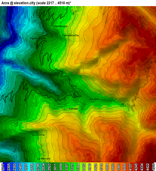
Below is the Elevation map of Anra, which displays elevation range with different colors. Scale of the first map is from 2217 to 4510 m (7274 to 14797 ft) with average elevation of 3487.8 meters (=11443 ft) [note 1]
These maps also provides idea of topography and contour of this city, they are displayed at different zoom levels. More info about maps, scale and edge coordinates you can find below images.
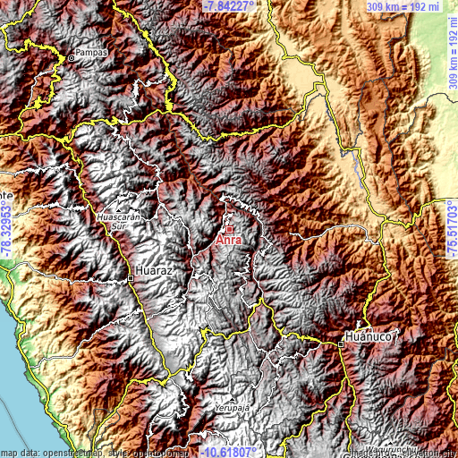
| \ | Map #1 | Topo.Map |
| Scale [m] | 2217..4510 m | × |
| Scale [ft] | 7274..14797 ft | × |
| Average | 3487.8 m = 11443 ft | × |
| Width | 9.65 km = 6 mi | 308.6 km = 191.8 mi |
| Height | 9.65 km = 6 mi | 308.7 km = 191.8 mi |
| ↑Max Latitude | -9.189521° | -7.84227° |
| Latitude at center | -9.2329° | -9.2329° |
| ↓Min Latitude | -9.276273° | -10.61807° |
| ← Min Longitude | -76.967225° | -78.32953° |
| Longitude center | -76.92328° | -76.92328° |
| →Max Longitude | -76.879335° | -75.51703° |
Nearby cities:
Cities around Anra sort by population:
• Llata elevation 2808 m
25.6 km,  143°
143°
• Huacaybamba 3165 m
21.9 km,  351°
351°
• Singa 3642 m
21 km, 144°
• Arancay 3079 m
20.3 km,  70°
70°
• Rapayan 3217 m
18.3 km,  79°
79°
• Cochabamba 3278 m
18 km,  31°
31°
• Huacchis 3467 m
15.3 km, 76°
• Chingas 2852 m
14.6 km,  329°
329°
• Aczo 2668 m
11.6 km,  321°
321°
• Huacachi 3517 m
9.5 km,  190°
190°
• Paucas 3421 m
9.4 km,  16°
16°
• Uco 3350 m
5 km, 354°
Multilingual:
 En español:
Anra elevación 3290 m.
 En France:
Anra élévation 3290 m.


Sources and notes:
- [note 1] Map square and city borders are not equal. Map elevation data is calculated only from area inside that square.
- [src 1] Elevation data from geonames database provided with same terms of usage.
- [src 2] The elevation map of Anra is generated using elevation data from NASA's 3 arcsec (90m) resolution SRTM data.
- [src 3] Base (background) map © OpenStreetMap contributors tiles are generated by Geofabrik and OpenTopoMap.
Copyright & License:
This Anra Elevation Map is licensed under CC BY-SA. You may reuse any part from this page, if you give a proper credit by linking to this URL:
 More info on terms of use page.