Llata elevation
Llata (Huanuco, Provincia de Huamalíes), Peru elevation is 2808 meters and Llata elevation in feet is 9213 ft above sea level [src 1]. Llata is a populated place (feature code) with elevation that is 487 meters (1598 ft) bigger than average city elevation in Peru.
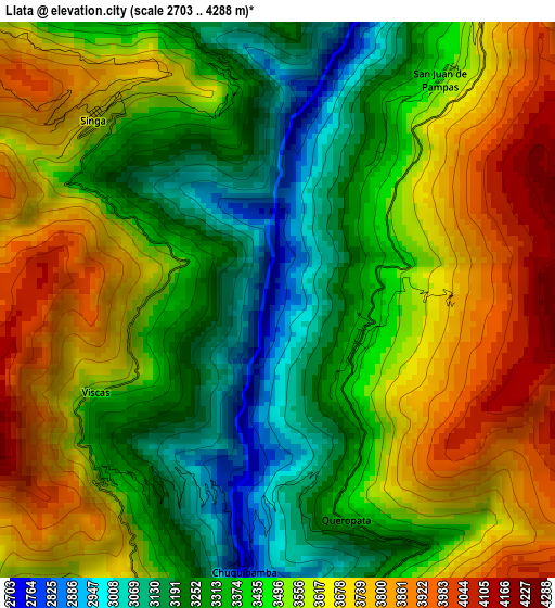
Below is the Elevation map of Llata, which displays elevation range with different colors. Scale of the first map is from 2703 to 4288 m (8868 to 14068 ft) with average elevation of 3488.2 meters (=11444 ft) [note 1]
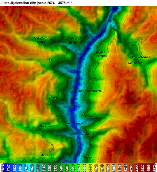
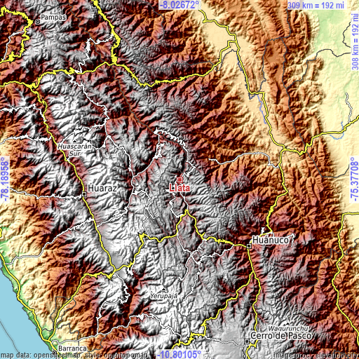
These maps also provides idea of topography and contour of this city, they are displayed at different zoom levels. More info about maps, scale and edge coordinates you can find below images.
| \ | Map #1 | Map #2 | Topo.Map |
| Scale [m] | 2703..4288 m | 2674..4578 m | × |
| Scale [ft] | 8868..14068 ft | 8773..15020 ft | × |
| Average | 3488.2 m = 11444 ft | 3776.2 m = 12389 ft | × |
| Width | 9.64 km = 6 mi | 19.28 km = 12 mi | 308.5 km = 191.7 mi |
| Height | 9.64 km = 6 mi | 19.28 km = 12 mi | 308.5 km = 191.7 mi |
| ↑Max Latitude | -9.373314° | -9.329953° | -8.02672° |
| Latitude at center | -9.41667° | -9.41667° | -9.41667° |
| ↓Min Latitude | -9.46002° | -9.503365° | -10.80105° |
| ← Min Longitude | -76.827275° | -76.871221° | -78.18958° |
| Longitude center | -76.78333° | -76.78333° | -76.78333° |
| →Max Longitude | -76.739385° | -76.695439° | -75.37708° |
Nearby cities:
Cities around Llata sort by population:
• Anra elevation 3290 m
25.6 km,  323°
323°
• Huacchis 3467 m
24.1 km,  358°
358°
• Rapayan 3217 m
23.9 km,  6°
6°
• Quivilla 2970 m
21.3 km,  162°
162°
• Huacachi 3517 m
20.4 km,  302°
302°
• Llata 3438 m
15.3 km,  193°
193°
• Jacas Grande 3617 m
14.6 km, 159°
• Puños 3664 m
14.3 km,  231°
231°
• Miraflores 3667 m
9.4 km,  204°
204°
• Tantamayo 3623 m
7.2 km,  66°
66°
• Punchao 3541 m
6.4 km,  218°
218°
• Singa 3642 m
4.6 km, 315°
Multilingual:
 En español:
Llata elevación 2808 m.
 En France:
Llata élévation 2808 m.


Sources and notes:
- [note 1] Map square and city borders are not equal. Map elevation data is calculated only from area inside that square.
- [src 1] Elevation data from geonames database provided with same terms of usage.
- [src 2] The elevation map of Llata is generated using elevation data from NASA's 3 arcsec (90m) resolution SRTM data.
- [src 3] Base (background) map © OpenStreetMap contributors tiles are generated by Geofabrik and OpenTopoMap.
Copyright & License:
This Llata Elevation Map is licensed under CC BY-SA. You may reuse any part from this page, if you give a proper credit by linking to this URL:
 More info on terms of use page.