Yanahuanca elevation
Yanahuanca (Pasco, Provincia de Daniel Carrión), Peru elevation is 3184 meters and Yanahuanca elevation in feet is 10446 ft above sea level [src 1]. Yanahuanca is a seat of a third-order administrative division (feature code) with elevation that is 863 meters (2831 ft) bigger than average city elevation in Peru.
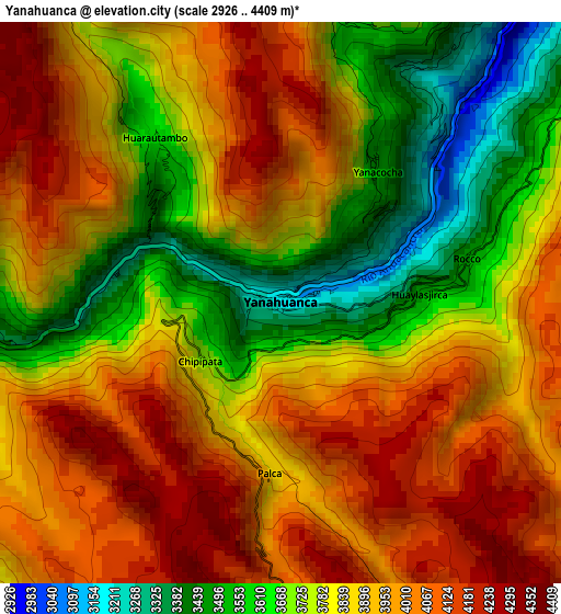
Below is the Elevation map of Yanahuanca, which displays elevation range with different colors. Scale of the first map is from 2926 to 4409 m (9600 to 14465 ft) with average elevation of 3853.3 meters (=12642 ft) [note 1]
These maps also provides idea of topography and contour of this city, they are displayed at different zoom levels. More info about maps, scale and edge coordinates you can find below images.
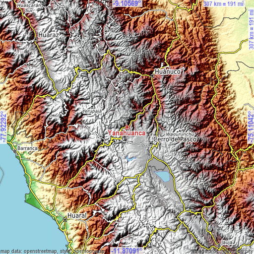
| \ | Map #1 | Topo.Map |
| Scale [m] | 2926..4409 m | × |
| Scale [ft] | 9600..14465 ft | × |
| Average | 3853.3 m = 12642 ft | × |
| Width | 9.61 km = 6 mi | 307.5 km = 191.1 mi |
| Height | 9.61 km = 6 mi | 307.5 km = 191.1 mi |
| ↑Max Latitude | -10.448176° | -9.10569° |
| Latitude at center | -10.49139° | -10.49139° |
| ↓Min Latitude | -10.534598° | -11.87091° |
| ← Min Longitude | -76.560615° | -77.92292° |
| Longitude center | -76.51667° | -76.51667° |
| →Max Longitude | -76.472725° | -75.11042° |
Nearby cities:
Cities around Yanahuanca sort by population:
• Cerro de Pasco elevation 4336 m
34.5 km,  124°
124°
• Chaupimarca 3446 m
11.1 km,  32°
32°
• Yanacancha 3997 m
31.2 km,  333°
333°
• Oyón 3617 m
34.1 km,  234°
234°
• Yanahuanca 4216 m
3.4 km,  144°
144°
• Pallanchacra 3124 m
31.9 km,  74°
74°
• Mosca 3471 m
29.6 km,  56°
56°
• Cayna 3332 m
28.1 km, 29°
• Colpas 2693 m
27.2 km,  24°
24°
• Paucar 3359 m
15.6 km, 30°
• Goyllarisquizga 4168 m
11.9 km,  80°
80°
• Vilcabamba 3444 m
7.7 km, 78°
Multilingual:
 En español:
Yanahuanca elevación 3184 m.
 En France:
Yanahuanca élévation 3184 m.
 Auf Deutsch:
Yanahuanca höhe über dem Meeresspiegel ist 3184 m.

Sources and notes:
- [note 1] Map square and city borders are not equal. Map elevation data is calculated only from area inside that square.
- [src 1] Elevation data from geonames database provided with same terms of usage.
- [src 2] The elevation map of Yanahuanca is generated using elevation data from NASA's 3 arcsec (90m) resolution SRTM data.
- [src 3] Base (background) map © OpenStreetMap contributors tiles are generated by Geofabrik and OpenTopoMap.
Copyright & License:
This Yanahuanca Elevation Map is licensed under CC BY-SA. You may reuse any part from this page, if you give a proper credit by linking to this URL:
 More info on terms of use page.