Urpay elevation
Urpay (La Libertad, Provincia de Pataz), Peru elevation is 2693 meters and Urpay elevation in feet is 8835 ft above sea level [src 1]. Urpay is a seat of a third-order administrative division (feature code) with elevation that is 372 meters (1220 ft) bigger than average city elevation in Peru.
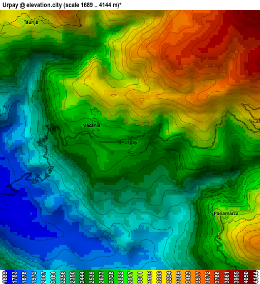
Below is the Elevation map of Urpay, which displays elevation range with different colors. Scale of the first map is from 1689 to 4144 m (5541 to 13596 ft) with average elevation of 2702.9 meters (=8868 ft) [note 1]
These maps also provides idea of topography and contour of this city, they are displayed at different zoom levels. More info about maps, scale and edge coordinates you can find below images.
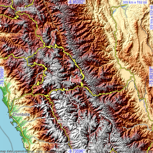
| \ | Map #1 | Topo.Map |
| Scale [m] | 1689..4144 m | × |
| Scale [ft] | 5541..13596 ft | × |
| Average | 2702.9 m = 8868 ft | × |
| Width | 9.67 km = 6 mi | 309.4 km = 192.3 mi |
| Height | 9.67 km = 6 mi | 309.4 km = 192.3 mi |
| ↑Max Latitude | -8.303738° | -6.95352° |
| Latitude at center | -8.34722° | -8.34722° |
| ↓Min Latitude | -8.390697° | -9.73596° |
| ← Min Longitude | -77.433385° | -78.79569° |
| Longitude center | -77.38944° | -77.38944° |
| →Max Longitude | -77.345495° | -75.98319° |
Nearby cities:
Cities around Urpay sort by population:
• Huacrachuco elevation 3955 m
47.6 km,  135°
135°
• Quinuabamba 4014 m
43 km,  176°
176°
• Parcoy 3140 m
36.2 km,  344°
344°
• Sihuas 2593 m
34.9 km,  225°
225°
• Chillia 4114 m
29.4 km, 339°
• Huaylillas 2391 m
18.5 km,  16°
16°
• Huancaspata 3306 m
15.8 km, 140°
• Tayabamba 3241 m
12.9 km,  52°
52°
• Ullulluco 3191 m
12.7 km,  198°
198°
• Challas 3296 m
12.7 km, 143°
• Quiches 3016 m
12.4 km,  244°
244°
• Taurija 3061 m
5.6 km,  320°
320°
Multilingual:
 En español:
Urpay elevación 2693 m.
 En France:
Urpay élévation 2693 m.


Sources and notes:
- [note 1] Map square and city borders are not equal. Map elevation data is calculated only from area inside that square.
- [src 1] Elevation data from geonames database provided with same terms of usage.
- [src 2] The elevation map of Urpay is generated using elevation data from NASA's 3 arcsec (90m) resolution SRTM data.
- [src 3] Base (background) map © OpenStreetMap contributors tiles are generated by Geofabrik and OpenTopoMap.
Copyright & License:
This Urpay Elevation Map is licensed under CC BY-SA. You may reuse any part from this page, if you give a proper credit by linking to this URL:
 More info on terms of use page.