Huarichancara elevation
Huarichancara (Arequipa, Provincia de Caylloma), Peru elevation is 4451 meters and Huarichancara elevation in feet is 14603 ft above sea level [src 1]. Huarichancara is a populated place (feature code) with elevation that is 2130 meters (6988 ft) bigger than average city elevation in Peru.
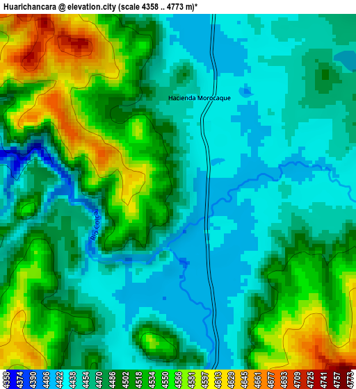
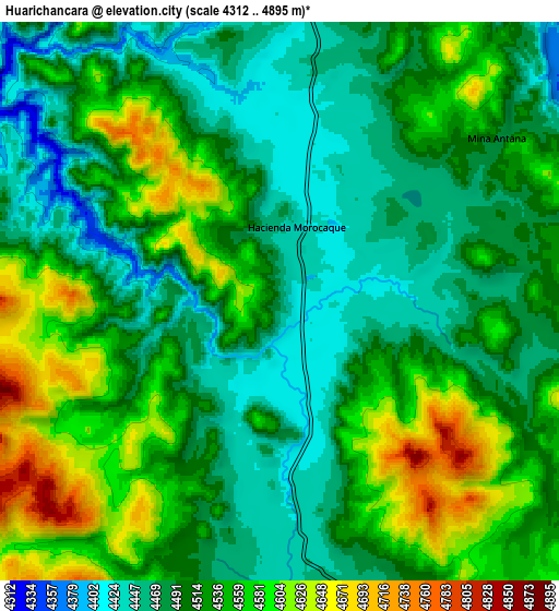
Below is the Elevation map of Huarichancara, which displays elevation range with different colors. Scale of the first map is from 4358 to 4773 m (14298 to 15659 ft) with average elevation of 4489.1 meters (=14728 ft) [note 1]
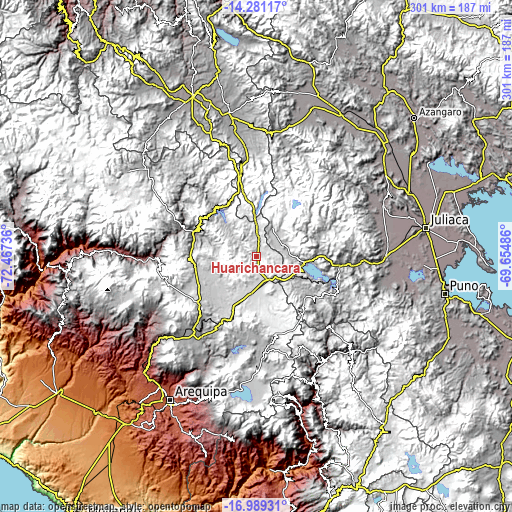
These maps also provides idea of topography and contour of this city, they are displayed at different zoom levels. More info about maps, scale and edge coordinates you can find below images.
| \ | Map #1 | Map #2 | Topo.Map |
| Scale [m] | 4358..4773 m | 4312..4895 m | × |
| Scale [ft] | 14298..15659 ft | 14147..16060 ft | × |
| Average | 4489.1 m = 14728 ft | 4520.9 m = 14832 ft | × |
| Width | 9.41 km = 5.8 mi | 18.82 km = 11.7 mi | 301.1 km = 187.1 mi |
| Height | 9.41 km = 5.8 mi | 18.82 km = 11.7 mi | 301.1 km = 187.1 mi |
| ↑Max Latitude | -15.597397° | -15.555066° | -14.28117° |
| Latitude at center | -15.63972° | -15.63972° | -15.63972° |
| ↓Min Latitude | -15.682034° | -15.724339° | -16.98931° |
| ← Min Longitude | -71.105055° | -71.149001° | -72.46736° |
| Longitude center | -71.06111° | -71.06111° | -71.06111° |
| →Max Longitude | -71.017165° | -70.973219° | -69.65486° |
Nearby cities:
Cities around Huarichancara sort by population:
• Hacienda Huancane elevation 4531 m
27.8 km,  137°
137°
• Llongasora 4622 m
25.5 km,  270°
270°
• Huarancante 4587 m
45 km,  251°
251°
• Vizcachane 4432 m
24 km,  218°
218°
• Jatun Orcochiri 4327 m
32.9 km, 248°
• Santa Lucía 4046 m
49.1 km,  97°
97°
• Jayune 4242 m
27.3 km,  288°
288°
• Ccolo 3860 m
48.5 km, 287°
• Tisco 4193 m
52.7 km,  308°
308°
• Sibayo 3822 m
45.8 km, 291°
• Condoroma 4803 m
44.5 km,  357°
357°
• Callalli 3878 m
43.7 km, 289°
Multilingual:
 En español:
Huarichancara elevación 4451 m.
 En France:
Huarichancara élévation 4451 m.
 Auf Deutsch:
Huarichancara höhe über dem Meeresspiegel ist 4451 m.

Sources and notes:
- [note 1] Map square and city borders are not equal. Map elevation data is calculated only from area inside that square.
- [src 1] Elevation data from geonames database provided with same terms of usage.
- [src 2] The elevation map of Huarichancara is generated using elevation data from NASA's 3 arcsec (90m) resolution SRTM data.
- [src 3] Base (background) map © OpenStreetMap contributors tiles are generated by Geofabrik and OpenTopoMap.
Copyright & License:
This Huarichancara Elevation Map is licensed under CC BY-SA. You may reuse any part from this page, if you give a proper credit by linking to this URL:
 More info on terms of use page.