Sabaino elevation
Sabaino (Apurímac, Provincia de Antabamba), Peru elevation is 3538 meters and Sabaino elevation in feet is 11608 ft above sea level [src 1]. Sabaino is a seat of a third-order administrative division (feature code) with elevation that is 1217 meters (3993 ft) bigger than average city elevation in Peru.
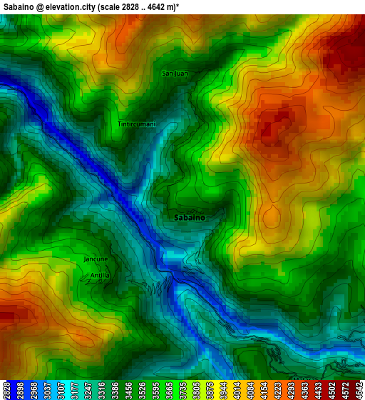
Below is the Elevation map of Sabaino, which displays elevation range with different colors. Scale of the first map is from 2828 to 4642 m (9278 to 15230 ft) with average elevation of 3625.4 meters (=11894 ft) [note 1]
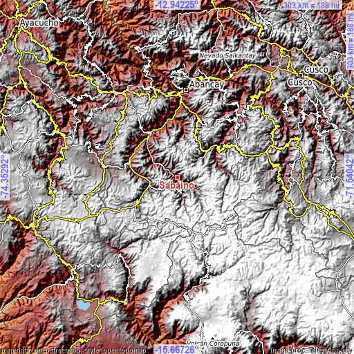
These maps also provides idea of topography and contour of this city, they are displayed at different zoom levels. More info about maps, scale and edge coordinates you can find below images.
| \ | Map #1 | Topo.Map |
| Scale [m] | 2828..4642 m | × |
| Scale [ft] | 9278..15230 ft | × |
| Average | 3625.4 m = 11894 ft | × |
| Width | 9.47 km = 5.9 mi | 303 km = 188.3 mi |
| Height | 9.47 km = 5.9 mi | 303 km = 188.3 mi |
| ↑Max Latitude | -14.266304° | -12.94225° |
| Latitude at center | -14.30889° | -14.30889° |
| ↓Min Latitude | -14.351468° | -15.66726° |
| ← Min Longitude | -72.990615° | -74.35292° |
| Longitude center | -72.94667° | -72.94667° |
| →Max Longitude | -72.902725° | -71.54042° |
Nearby cities:
Cities around Sabaino sort by population:
• Pataypampa elevation 3796 m
33 km,  63°
63°
• Chalhuanca 3004 m
30.6 km,  271°
271°
• Cotaruse 3328 m
30.5 km,  247°
247°
• Tapairihua 2753 m
28.3 km,  311°
311°
• Caraybamba 3336 m
24.3 km, 251°
• Yanaca 2963 m
23.3 km,  295°
295°
• Pocohuanca 3258 m
17.9 km, 304°
• Ayahuay 3045 m
17.1 km, 311°
• Mollebamba 3520 m
13.1 km,  163°
163°
• Pachaconas 3309 m
12.8 km,  318°
318°
• Antabamba 3494 m
9.6 km,  126°
126°
• Huaquirca 3798 m
6.6 km,  112°
112°
Multilingual:
 En español:
Sabaino elevación 3538 m.
 En France:
Sabaino élévation 3538 m.
 Auf Deutsch:
Sabaino höhe über dem Meeresspiegel ist 3538 m.

Sources and notes:
- [note 1] Map square and city borders are not equal. Map elevation data is calculated only from area inside that square.
- [src 1] Elevation data from geonames database provided with same terms of usage.
- [src 2] The elevation map of Sabaino is generated using elevation data from NASA's 3 arcsec (90m) resolution SRTM data.
- [src 3] Base (background) map © OpenStreetMap contributors tiles are generated by Geofabrik and OpenTopoMap.
Copyright & License:
This Sabaino Elevation Map is licensed under CC BY-SA. You may reuse any part from this page, if you give a proper credit by linking to this URL:
 More info on terms of use page.