Yanaca elevation
Yanaca (Apurímac, Provincia de Aymaraes), Peru elevation is 2963 meters and Yanaca elevation in feet is 9721 ft above sea level [src 1]. Yanaca is a seat of a third-order administrative division (feature code) with elevation that is 642 meters (2106 ft) bigger than average city elevation in Peru.
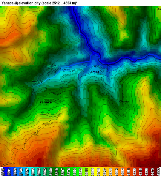
Below is the Elevation map of Yanaca, which displays elevation range with different colors. Scale of the first map is from 2512 to 4553 m (8241 to 14938 ft) with average elevation of 3430.5 meters (=11255 ft) [note 1]
These maps also provides idea of topography and contour of this city, they are displayed at different zoom levels. More info about maps, scale and edge coordinates you can find below images.
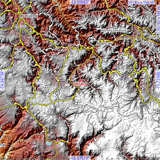
| \ | Map #1 | Topo.Map |
| Scale [m] | 2512..4553 m | × |
| Scale [ft] | 8241..14938 ft | × |
| Average | 3430.5 m = 11255 ft | × |
| Width | 9.47 km = 5.9 mi | 303.1 km = 188.3 mi |
| Height | 9.47 km = 5.9 mi | 303.1 km = 188.3 mi |
| ↑Max Latitude | -14.175177° | -12.85062° |
| Latitude at center | -14.21778° | -14.21778° |
| ↓Min Latitude | -14.260375° | -15.57673° |
| ← Min Longitude | -73.185055° | -74.54736° |
| Longitude center | -73.14111° | -73.14111° |
| →Max Longitude | -73.097165° | -71.73486° |
Nearby cities:
Cities around Yanaca sort by population:
• Sabaino elevation 3538 m
23.3 km,  115°
115°
• Cotaruse 3328 m
23.2 km,  198°
198°
• Capaya 3264 m
22 km,  299°
299°
• Sañayca 3081 m
21 km,  273°
273°
• Soraya 2879 m
19.5 km,  288°
288°
• Caraybamba 3336 m
17.9 km,  187°
187°
• Huayllo 3135 m
16.7 km, 304°
• Chalhuanca 3004 m
13.3 km,  226°
226°
• Pachaconas 3309 m
12.5 km,  92°
92°
• Tapairihua 2753 m
8.6 km,  358°
358°
• Ayahuay 3045 m
8.1 km,  82°
82°
• Pocohuanca 3258 m
6.2 km, 88°
Multilingual:
 En español:
Yanaca elevación 2963 m.
 En France:
Yanaca élévation 2963 m.


Sources and notes:
- [note 1] Map square and city borders are not equal. Map elevation data is calculated only from area inside that square.
- [src 1] Elevation data from geonames database provided with same terms of usage.
- [src 2] The elevation map of Yanaca is generated using elevation data from NASA's 3 arcsec (90m) resolution SRTM data.
- [src 3] Base (background) map © OpenStreetMap contributors tiles are generated by Geofabrik and OpenTopoMap.
Copyright & License:
This Yanaca Elevation Map is licensed under CC BY-SA. You may reuse any part from this page, if you give a proper credit by linking to this URL:
 More info on terms of use page.