Camaná elevation
Camaná (Arequipa, Provincia de Camaná), Peru elevation is 16 meters and Camaná elevation in feet is 52 ft above sea level [src 1]. Camaná is a populated place (feature code) with elevation that is 2305 meters (7562 ft) smaller than average city elevation in Peru.
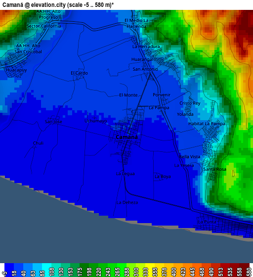
Below is the Elevation map of Camaná, which displays elevation range with different colors. Scale of the first map is from -5 to 580 m (-16 to 1903 ft) with average elevation of 88 meters (=289 ft) [note 1]
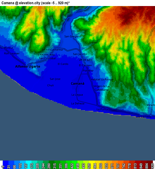
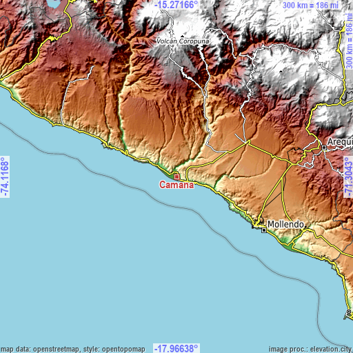
These maps also provides idea of topography and contour of this city, they are displayed at different zoom levels. More info about maps, scale and edge coordinates you can find below images.
| \ | Map #1 | Map #2 | Topo.Map |
| Scale [m] | -5..580 m | -5..920 m | × |
| Scale [ft] | -16..1903 ft | -16..3018 ft | × |
| Average | 88 m = 289 ft | 261.1 m = 857 ft | × |
| Width | 9.36 km = 5.8 mi | 18.73 km = 11.6 mi | 299.6 km = 186.2 mi |
| Height | 9.36 km = 5.8 mi | 18.73 km = 11.6 mi | 299.6 km = 186.2 mi |
| ↑Max Latitude | -16.581637° | -16.539514° | -15.27166° |
| Latitude at center | -16.62375° | -16.62375° | -16.62375° |
| ↓Min Latitude | -16.665854° | -16.707949° | -17.96638° |
| ← Min Longitude | -72.754495° | -72.798441° | -74.1168° |
| Longitude center | -72.71055° | -72.71055° | -72.71055° |
| →Max Longitude | -72.666605° | -72.622659° | -71.3043° |
Nearby cities:
Cities around Camaná sort by population:
• Mollendo elevation 70 m
86.3 km,  120°
120°
• Iquipi 504 m
88.2 km,  329°
329°
• Chuquibamba 2926 m
87.6 km,  3°
3°
• Iray 2403 m
85.8 km,  6°
6°
• Urasqui 348 m
82.4 km,  323°
323°
• Aplao 648 m
65.2 km,  20°
20°
• Huancarqui 603 m
63.9 km, 23°
• Corire 434 m
51.3 km,  29°
29°
• Ocoña 11 m
47.4 km,  296°
296°
• Quilca 11 m
31 km,  108°
108°
• El Cardo 25 m
2.8 km, 323°
• La Pampa 27 m
1.9 km,  53°
53°
Multilingual:
 En español:
Camaná elevación 16 m.
 En France:
Camaná élévation 16 m.


Sources and notes:
- [note 1] Map square and city borders are not equal. Map elevation data is calculated only from area inside that square.
- [src 1] Elevation data from geonames database provided with same terms of usage.
- [src 2] The elevation map of Camaná is generated using elevation data from NASA's 3 arcsec (90m) resolution SRTM data.
- [src 3] Base (background) map © OpenStreetMap contributors tiles are generated by Geofabrik and OpenTopoMap.
Copyright & License:
This Camaná Elevation Map is licensed under CC BY-SA. You may reuse any part from this page, if you give a proper credit by linking to this URL:
 More info on terms of use page.