Cayarani elevation
Cayarani (Arequipa, Provincia de Condesuyos), Peru elevation is 3929 meters and Cayarani elevation in feet is 12890 ft above sea level [src 1]. Cayarani is a seat of a third-order administrative division (feature code) with elevation that is 1608 meters (5276 ft) bigger than average city elevation in Peru.
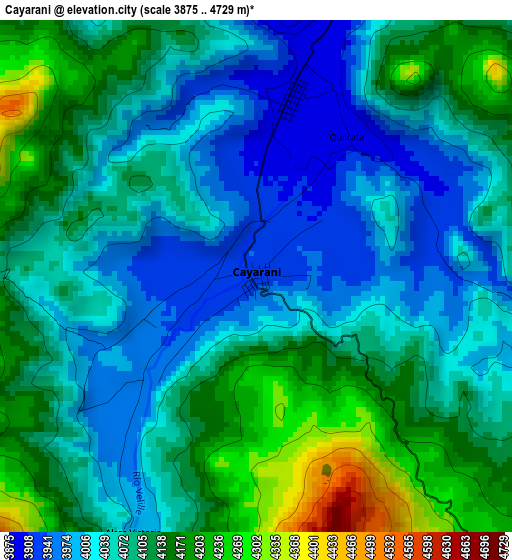
Below is the Elevation map of Cayarani, which displays elevation range with different colors. Scale of the first map is from 3875 to 4729 m (12713 to 15515 ft) with average elevation of 4080.8 meters (=13388 ft) [note 1]
These maps also provides idea of topography and contour of this city, they are displayed at different zoom levels. More info about maps, scale and edge coordinates you can find below images.
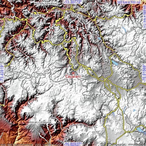
| \ | Map #1 | Topo.Map |
| Scale [m] | 3875..4729 m | × |
| Scale [ft] | 12713..15515 ft | × |
| Average | 4080.8 m = 13388 ft | × |
| Width | 9.45 km = 5.9 mi | 302.5 km = 188 mi |
| Height | 9.45 km = 5.9 mi | 302.5 km = 188 mi |
| ↑Max Latitude | -14.629704° | -13.30772° |
| Latitude at center | -14.67222° | -14.67222° |
| ↓Min Latitude | -14.714728° | -16.02827° |
| ← Min Longitude | -72.065885° | -73.42819° |
| Longitude center | -72.02194° | -72.02194° |
| →Max Longitude | -71.977995° | -70.61569° |
Nearby cities:
Cities around Cayarani sort by population:
• Santo Tomas elevation 3659 m
26.1 km,  345°
345°
• Challhuahuacho 3716 m
66.5 km,  338°
338°
• Mara 3788 m
65.9 km, 351°
• Pichigua 3866 m
65.1 km,  90°
90°
• Livitaca 3641 m
54.7 km,  41°
41°
• Coporaque 3949 m
54.5 km,  105°
105°
• Haquira 3702 m
54.2 km, 340°
• Chamaca 3787 m
44.8 km,  25°
25°
• Colquemarca 3578 m
43.4 km,  357°
357°
• Quiñota 3618 m
42.3 km, 343°
• Llusco 3517 m
39.2 km, 345°
• Velille 3743 m
23.4 km, 38°
Multilingual:
 En español:
Cayarani elevación 3929 m.
 En France:
Cayarani élévation 3929 m.
 Auf Deutsch:
Cayarani höhe über dem Meeresspiegel ist 3929 m.

Sources and notes:
- [note 1] Map square and city borders are not equal. Map elevation data is calculated only from area inside that square.
- [src 1] Elevation data from geonames database provided with same terms of usage.
- [src 2] The elevation map of Cayarani is generated using elevation data from NASA's 3 arcsec (90m) resolution SRTM data.
- [src 3] Base (background) map © OpenStreetMap contributors tiles are generated by Geofabrik and OpenTopoMap.
Copyright & License:
This Cayarani Elevation Map is licensed under CC BY-SA. You may reuse any part from this page, if you give a proper credit by linking to this URL:
 More info on terms of use page.