Challhuahuacho elevation
Challhuahuacho (Apurímac, Provincia de Cotabambas), Peru elevation is 3716 meters and Challhuahuacho elevation in feet is 12192 ft above sea level [src 1]. Challhuahuacho is a seat of a third-order administrative division (feature code) with elevation that is 1395 meters (4577 ft) bigger than average city elevation in Peru.
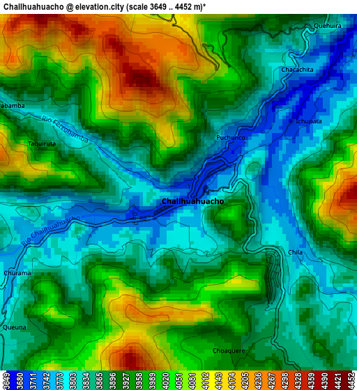
Below is the Elevation map of Challhuahuacho, which displays elevation range with different colors. Scale of the first map is from 3649 to 4452 m (11972 to 14606 ft) with average elevation of 3928.4 meters (=12888 ft) [note 1]
These maps also provides idea of topography and contour of this city, they are displayed at different zoom levels. More info about maps, scale and edge coordinates you can find below images.
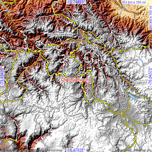
| \ | Map #1 | Topo.Map |
| Scale [m] | 3649..4452 m | × |
| Scale [ft] | 11972..14606 ft | × |
| Average | 3928.4 m = 12888 ft | × |
| Width | 9.48 km = 5.9 mi | 303.2 km = 188.4 mi |
| Height | 9.48 km = 5.9 mi | 303.3 km = 188.5 mi |
| ↑Max Latitude | -14.074048° | -12.74893° |
| Latitude at center | -14.11667° | -14.11667° |
| ↓Min Latitude | -14.159284° | -15.47625° |
| ← Min Longitude | -72.293945° | -73.65625° |
| Longitude center | -72.25° | -72.25° |
| →Max Longitude | -72.206055° | -70.84375° |
Nearby cities:
Cities around Challhuahuacho sort by population:
• Coyllurqui elevation 3174 m
36.8 km,  327°
327°
• Oropesa 3598 m
36.4 km,  244°
244°
• Ccapi 3196 m
34.7 km,  32°
32°
• Huayllati 3450 m
32.8 km,  309°
309°
• Capacmarca 3624 m
29.7 km,  66°
66°
• Colquemarca 3578 m
29 km,  129°
129°
• Llusco 3517 m
27.9 km,  148°
148°
• Progreso 3932 m
24.5 km,  281°
281°
• Quiñota 3618 m
24.5 km, 149°
• Tambobamba 3227 m
20.9 km,  23°
23°
• Mara 3788 m
15.7 km,  77°
77°
• Haquira 3702 m
12.5 km, 148°
Multilingual:
 En español:
Challhuahuacho elevación 3716 m.
 En France:
Challhuahuacho élévation 3716 m.
 Auf Deutsch:
Challhuahuacho höhe über dem Meeresspiegel ist 3716 m.

Sources and notes:
- [note 1] Map square and city borders are not equal. Map elevation data is calculated only from area inside that square.
- [src 1] Elevation data from geonames database provided with same terms of usage.
- [src 2] The elevation map of Challhuahuacho is generated using elevation data from NASA's 3 arcsec (90m) resolution SRTM data.
- [src 3] Base (background) map © OpenStreetMap contributors tiles are generated by Geofabrik and OpenTopoMap.
Copyright & License:
This Challhuahuacho Elevation Map is licensed under CC BY-SA. You may reuse any part from this page, if you give a proper credit by linking to this URL:
 More info on terms of use page.