Oropesa elevation
Oropesa (Apurímac, Provincia de Antabamba), Peru elevation is 3598 meters and Oropesa elevation in feet is 11804 ft above sea level [src 1]. Oropesa is a seat of a third-order administrative division (feature code) with elevation that is 1277 meters (4190 ft) bigger than average city elevation in Peru.
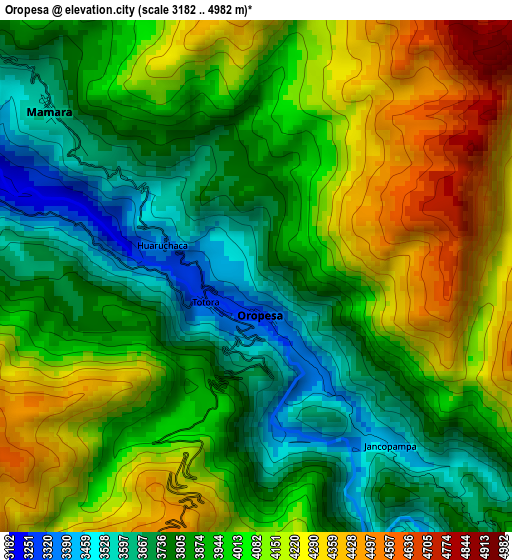
Below is the Elevation map of Oropesa, which displays elevation range with different colors. Scale of the first map is from 3182 to 4982 m (10440 to 16345 ft) with average elevation of 3962.1 meters (=12999 ft) [note 1]
These maps also provides idea of topography and contour of this city, they are displayed at different zoom levels. More info about maps, scale and edge coordinates you can find below images.
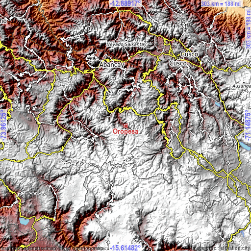
| \ | Map #1 | Topo.Map |
| Scale [m] | 3182..4982 m | × |
| Scale [ft] | 10440..16345 ft | × |
| Average | 3962.1 m = 12999 ft | × |
| Width | 9.47 km = 5.9 mi | 303.1 km = 188.3 mi |
| Height | 9.47 km = 5.9 mi | 303.1 km = 188.3 mi |
| ↑Max Latitude | -14.213514° | -12.88917° |
| Latitude at center | -14.25611° | -14.25611° |
| ↓Min Latitude | -14.298698° | -15.61482° |
| ← Min Longitude | -72.598945° | -73.96125° |
| Longitude center | -72.555° | -72.555° |
| →Max Longitude | -72.511055° | -71.14875° |
Nearby cities:
Cities around Oropesa sort by population:
• Antabamba elevation 3494 m
36.4 km,  251°
251°
• Challhuahuacho 3716 m
36.4 km,  64°
64°
• Curpahuasi 3496 m
24.9 km,  330°
330°
• Chuquibambilla 3301 m
23.7 km,  316°
316°
• Progreso 3932 m
22.3 km,  23°
23°
• Vilcabamba 2780 m
21.5 km,  339°
339°
• Ayrihuanca 3565 m
17.9 km, 339°
• Santa Rosa 3817 m
16.9 km,  314°
314°
• Pataypampa 3796 m
15.7 km, 305°
• San Antonio 3655 m
12.4 km, 324°
• Turpay 3224 m
8.5 km,  298°
298°
• Mamara 3737 m
4.5 km, 311°
Multilingual:
 En español:
Oropesa elevación 3598 m.
 En France:
Oropesa élévation 3598 m.
 Auf Deutsch:
Oropesa höhe über dem Meeresspiegel ist 3598 m.

Sources and notes:
- [note 1] Map square and city borders are not equal. Map elevation data is calculated only from area inside that square.
- [src 1] Elevation data from geonames database provided with same terms of usage.
- [src 2] The elevation map of Oropesa is generated using elevation data from NASA's 3 arcsec (90m) resolution SRTM data.
- [src 3] Base (background) map © OpenStreetMap contributors tiles are generated by Geofabrik and OpenTopoMap.
Copyright & License:
This Oropesa Elevation Map is licensed under CC BY-SA. You may reuse any part from this page, if you give a proper credit by linking to this URL:
 More info on terms of use page.