Chapimarca elevation
Chapimarca (Apurímac, Provincia de Aymaraes), Peru elevation is 3406 meters and Chapimarca elevation in feet is 11175 ft above sea level [src 1]. Chapimarca is a seat of a third-order administrative division (feature code) with elevation that is 1085 meters (3560 ft) bigger than average city elevation in Peru.
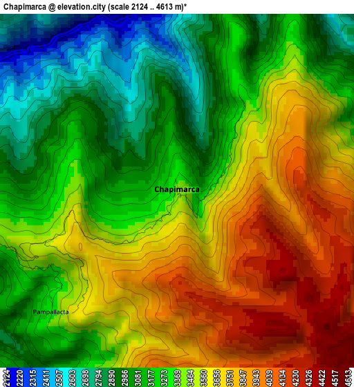
Below is the Elevation map of Chapimarca, which displays elevation range with different colors. Scale of the first map is from 2124 to 4613 m (6969 to 15135 ft) with average elevation of 3404.9 meters (=11171 ft) [note 1]
These maps also provides idea of topography and contour of this city, they are displayed at different zoom levels. More info about maps, scale and edge coordinates you can find below images.
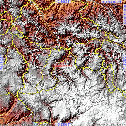
| \ | Map #1 | Topo.Map |
| Scale [m] | 2124..4613 m | × |
| Scale [ft] | 6969..15135 ft | × |
| Average | 3404.9 m = 11171 ft | × |
| Width | 9.48 km = 5.9 mi | 303.4 km = 188.5 mi |
| Height | 9.48 km = 5.9 mi | 303.5 km = 188.6 mi |
| ↑Max Latitude | -13.932632° | -12.60673° |
| Latitude at center | -13.97528° | -13.97528° |
| ↓Min Latitude | -14.017921° | -15.33574° |
| ← Min Longitude | -73.108945° | -74.47125° |
| Longitude center | -73.065° | -73.065° |
| →Max Longitude | -73.021055° | -71.65875° |
Nearby cities:
Cities around Chapimarca sort by population:
• Yanaca elevation 2963 m
28.2 km,  196°
196°
• Huayllo 3135 m
28.1 km,  231°
231°
• Pachaconas 3309 m
27.8 km,  171°
171°
• Pocohuanca 3258 m
26.9 km,  184°
184°
• Toraya 3171 m
26.4 km,  251°
251°
• Ayahuay 3045 m
25.9 km, 180°
• Circa 3439 m
23.6 km,  61°
61°
• Tapairihua 2753 m
20.2 km, 204°
• Colcabamba 3158 m
20 km,  259°
259°
• Lucre 2797 m
17.6 km,  279°
279°
• Tintay 2780 m
13.2 km, 277°
• Pichirhua 2746 m
12.8 km,  355°
355°
Multilingual:
 En español:
Chapimarca elevación 3406 m.
 En France:
Chapimarca élévation 3406 m.
 Auf Deutsch:
Chapimarca höhe über dem Meeresspiegel ist 3406 m.

Sources and notes:
- [note 1] Map square and city borders are not equal. Map elevation data is calculated only from area inside that square.
- [src 1] Elevation data from geonames database provided with same terms of usage.
- [src 2] The elevation map of Chapimarca is generated using elevation data from NASA's 3 arcsec (90m) resolution SRTM data.
- [src 3] Base (background) map © OpenStreetMap contributors tiles are generated by Geofabrik and OpenTopoMap.
Copyright & License:
This Chapimarca Elevation Map is licensed under CC BY-SA. You may reuse any part from this page, if you give a proper credit by linking to this URL:
 More info on terms of use page.