Cieneguilla elevation
Cieneguilla (Lima region, Lima), Peru elevation is 272 meters and Cieneguilla elevation in feet is 892 ft above sea level [src 1]. Cieneguilla is a seat of a third-order administrative division (feature code) with elevation that is 2049 meters (6722 ft) smaller than average city elevation in Peru.
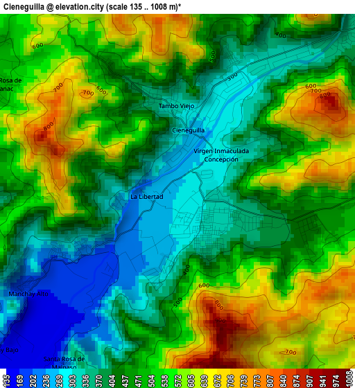
Below is the Elevation map of Cieneguilla, which displays elevation range with different colors. Scale of the first map is from 135 to 1008 m (443 to 3307 ft) with average elevation of 473 meters (=1552 ft) [note 1]
These maps also provides idea of topography and contour of this city, they are displayed at different zoom levels. More info about maps, scale and edge coordinates you can find below images.
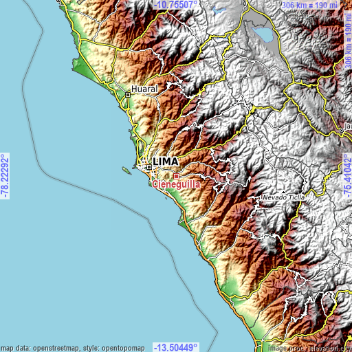
| \ | Map #1 | Topo.Map |
| Scale [m] | 135..1008 m | × |
| Scale [ft] | 443..3307 ft | × |
| Average | 473 m = 1552 ft | × |
| Width | 9.55 km = 5.9 mi | 305.7 km = 190 mi |
| Height | 9.55 km = 5.9 mi | 305.7 km = 190 mi |
| ↑Max Latitude | -12.090363° | -10.75507° |
| Latitude at center | -12.13333° | -12.13333° |
| ↓Min Latitude | -12.17629° | -13.50449° |
| ← Min Longitude | -76.860615° | -78.22292° |
| Longitude center | -76.81667° | -76.81667° |
| →Max Longitude | -76.772725° | -75.41042° |
Nearby cities:
Cities around Cieneguilla sort by population:
• Lima elevation 152 m
25.1 km,  293°
293°
• Santiago de Surco 92 m
20.7 km,  269°
269°
• Chosica 831 m
24.2 km,  28°
28°
• San Isidro 6 m
25.4 km, 274°
• Santa María 545 m
16.5 km,  329°
329°
• San Luis 191 m
20.3 km, 288°
• Asentamiento Humano Nicolas de Pierola 1016 m
25 km, 28°
• San Bartolo 22 m
28 km,  172°
172°
• Punta Hermosa 54 m
22.2 km,  180°
180°
• Chaclacayo 835 m
17.6 km,  17°
17°
• Vitarte 330 m
16.9 km,  311°
311°
• La Molina 236 m
15.5 km, 290°
Multilingual:
 En español:
Cieneguilla elevación 272 m.
 En France:
Cieneguilla élévation 272 m.
 Auf Deutsch:
Cieneguilla höhe über dem Meeresspiegel ist 272 m.

Sources and notes:
- [note 1] Map square and city borders are not equal. Map elevation data is calculated only from area inside that square.
- [src 1] Elevation data from geonames database provided with same terms of usage.
- [src 2] The elevation map of Cieneguilla is generated using elevation data from NASA's 3 arcsec (90m) resolution SRTM data.
- [src 3] Base (background) map © OpenStreetMap contributors tiles are generated by Geofabrik and OpenTopoMap.
Copyright & License:
This Cieneguilla Elevation Map is licensed under CC BY-SA. You may reuse any part from this page, if you give a proper credit by linking to this URL:
 More info on terms of use page.