Huarmey elevation
Huarmey (Ancash, Provincia de Huarmey), Peru elevation is 13 meters and Huarmey elevation in feet is 43 ft above sea level [src 1]. Huarmey is a seat of a third-order administrative division (feature code) with elevation that is 2308 meters (7572 ft) smaller than average city elevation in Peru.
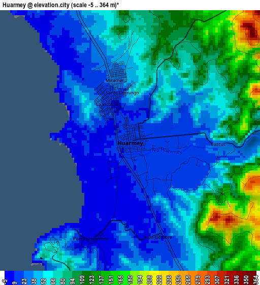
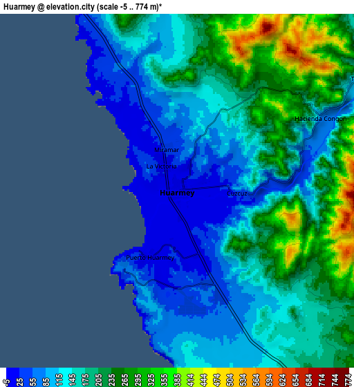
Below is the Elevation map of Huarmey, which displays elevation range with different colors. Scale of the first map is from -5 to 364 m (-16 to 1194 ft) with average elevation of 62.8 meters (=206 ft) [note 1]
These maps also provides idea of topography and contour of this city, they are displayed at different zoom levels. More info about maps, scale and edge coordinates you can find below images.
| \ | Map #1 | Map #2 | Topo.Map |
| Scale [m] | -5..364 m | -5..774 m | × |
| Scale [ft] | -16..1194 ft | -16..2539 ft | × |
| Average | 62.8 m = 206 ft | 169.3 m = 555 ft | × |
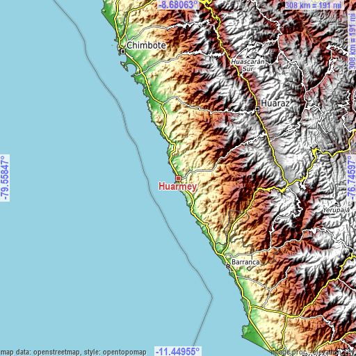
| Width | 9.62 km = 6 mi | 19.24 km = 12 mi | 307.9 km = 191.3 mi |
| Height | 9.62 km = 6 mi | 19.24 km = 12 mi | 307.9 km = 191.3 mi |
| ↑Max Latitude | -10.024789° | -9.981511° | -8.68063° |
| Latitude at center | -10.06806° | -10.06806° | -10.06806° |
| ↓Min Latitude | -10.111326° | -10.154586° | -11.44955° |
| ← Min Longitude | -78.196165° | -78.240111° | -79.55847° |
| Longitude center | -78.15222° | -78.15222° | -78.15222° |
| →Max Longitude | -78.108275° | -78.064329° | -76.74597° |
Nearby cities:
Cities around Huarmey sort by population:
• Chasquitambo elevation 874 m
65.7 km,  113°
113°
• Cajamarquilla 3242 m
65.4 km,  42°
42°
• Colcabamba 2807 m
65.2 km,  34°
34°
• Tapacocha 3480 m
62.5 km,  84°
84°
• Cotaparaco 3296 m
60.9 km, 82°
• Succha 3554 m
60.9 km,  64°
64°
• Llacllin 3116 m
58.6 km,  89°
89°
• Pampas 3898 m
56.7 km, 38°
• Malvas 2680 m
54 km,  71°
71°
• Coris 2448 m
51.2 km, 59°
• Huanchay 1880 m
51 km, 43°
• La Caleta Culebras 20 m
15.5 km,  328°
328°
Multilingual:
 En español:
Huarmey elevación 13 m.
 En France:
Huarmey élévation 13 m.


Sources and notes:
- [note 1] Map square and city borders are not equal. Map elevation data is calculated only from area inside that square.
- [src 1] Elevation data from geonames database provided with same terms of usage.
- [src 2] The elevation map of Huarmey is generated using elevation data from NASA's 3 arcsec (90m) resolution SRTM data.
- [src 3] Base (background) map © OpenStreetMap contributors tiles are generated by Geofabrik and OpenTopoMap.
Copyright & License:
This Huarmey Elevation Map is licensed under CC BY-SA. You may reuse any part from this page, if you give a proper credit by linking to this URL:
 More info on terms of use page.